You are here: Home > Network List > TA - USArray Transportable Network (new EarthScope stations) Stations List
> Station 255A Hazlehurst, GA, USA > Earthquake Result Viewer
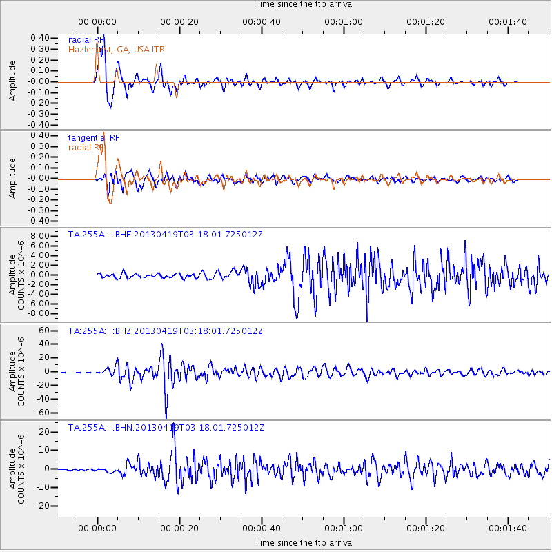
255A Hazlehurst, GA, USA - Earthquake Result Viewer
*The percent match for this event was below the threshold and hence no stack was calculated.
| Earthquake location: |
Kuril Islands |
| Earthquake latitude/longitude: |
46.2/150.8 |
| Earthquake time(UTC): |
2013/04/19 (109) 03:05:52 GMT |
| Earthquake Depth: |
110 km |
| Earthquake Magnitude: |
7.2 MW, 7.1 MB, 7.2 MW |
| Earthquake Catalog/Contributor: |
NEIC PDE/NEIC PDE-W |
|
| Network: |
TA USArray Transportable Network (new EarthScope stations) |
| Station: |
255A Hazlehurst, GA, USA |
| Lat/Lon: |
31.93 N/82.48 W |
| Elevation: |
45 m |
|
| Distance: |
88.5 deg |
| Az: |
42.974 deg |
| Baz: |
326.18 deg |
| Ray Param: |
$rayparam |
*The percent match for this event was below the threshold and hence was not used in the summary stack. |
|
| Radial Match: |
95.12326 % |
| Radial Bump: |
386 |
| Transverse Match: |
92.12866 % |
| Transverse Bump: |
400 |
| SOD ConfigId: |
512894 |
| Insert Time: |
2013-09-13 11:32:50.874 +0000 |
| GWidth: |
2.5 |
| Max Bumps: |
400 |
| Tol: |
0.001 |
|
Signal To Noise
| Channel | StoN | STA | LTA |
| TA:255A: :BHZ:20130419T03:18:01.725012Z | 27.479404 | 6.028556E-6 | 2.1938452E-7 |
| TA:255A: :BHN:20130419T03:18:01.725012Z | 2.777618 | 8.9668987E-7 | 3.2282693E-7 |
| TA:255A: :BHE:20130419T03:18:01.725012Z | 2.0209286 | 8.199203E-7 | 4.0571462E-7 |
| Arrivals |
| Ps | |
| PpPs | |
| PsPs/PpSs | |


