You are here: Home > Network List > TA - USArray Transportable Network (new EarthScope stations) Stations List
> Station 356A Blackshear, GA, USA > Earthquake Result Viewer
356A Blackshear, GA, USA - Earthquake Result Viewer
| Earthquake location: |
Kuril Islands |
| Earthquake latitude/longitude: |
46.2/150.8 |
| Earthquake time(UTC): |
2013/04/19 (109) 03:05:52 GMT |
| Earthquake Depth: |
110 km |
| Earthquake Magnitude: |
7.2 MW, 7.1 MB, 7.2 MW |
| Earthquake Catalog/Contributor: |
NEIC PDE/NEIC PDE-W |
|
| Network: |
TA USArray Transportable Network (new EarthScope stations) |
| Station: |
356A Blackshear, GA, USA |
| Lat/Lon: |
31.32 N/82.13 W |
| Elevation: |
36 m |
|
| Distance: |
89.2 deg |
| Az: |
43.06 deg |
| Baz: |
326.363 deg |
| Ray Param: |
0.04180271 |
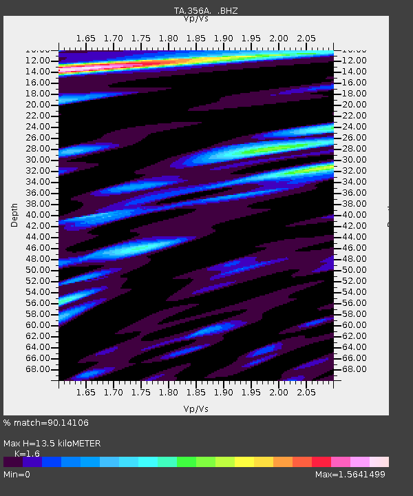
| Estimated Moho Depth: |
13.5 km |
| Estimated Crust Vp/Vs: |
1.60 |
| Assumed Crust Vp: |
6.565 km/s |
| Estimated Crust Vs: |
4.103 km/s |
| Estimated Crust Poisson's Ratio: |
0.18 |
|
| Radial Match: |
90.14106 % |
| Radial Bump: |
400 |
| Transverse Match: |
83.17181 % |
| Transverse Bump: |
400 |
| SOD ConfigId: |
512894 |
| Insert Time: |
2013-09-13 11:33:19.681 +0000 |
| GWidth: |
2.5 |
| Max Bumps: |
400 |
| Tol: |
0.001 |
|
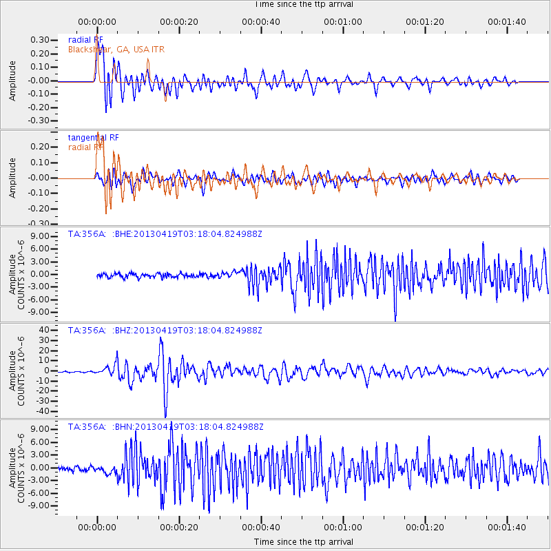
Signal To Noise
| Channel | StoN | STA | LTA |
| TA:356A: :BHZ:20130419T03:18:04.824988Z | 13.879547 | 5.3716567E-6 | 3.870196E-7 |
| TA:356A: :BHN:20130419T03:18:04.824988Z | 1.9793847 | 8.077303E-7 | 4.0807143E-7 |
| TA:356A: :BHE:20130419T03:18:04.824988Z | 1.4946659 | 6.734124E-7 | 4.5054378E-7 |
| Arrivals |
| Ps | 1.3 SECOND |
| PpPs | 5.2 SECOND |
| PsPs/PpSs | 6.5 SECOND |


