You are here: Home > Network List > TA - USArray Transportable Network (new EarthScope stations) Stations List
> Station 357A Townsend, GA, USA > Earthquake Result Viewer
357A Townsend, GA, USA - Earthquake Result Viewer
| Earthquake location: |
Kuril Islands |
| Earthquake latitude/longitude: |
46.2/150.8 |
| Earthquake time(UTC): |
2013/04/19 (109) 03:05:52 GMT |
| Earthquake Depth: |
110 km |
| Earthquake Magnitude: |
7.2 MW, 7.1 MB, 7.2 MW |
| Earthquake Catalog/Contributor: |
NEIC PDE/NEIC PDE-W |
|
| Network: |
TA USArray Transportable Network (new EarthScope stations) |
| Station: |
357A Townsend, GA, USA |
| Lat/Lon: |
31.42 N/81.49 W |
| Elevation: |
7.0 m |
|
| Distance: |
89.4 deg |
| Az: |
42.547 deg |
| Baz: |
326.689 deg |
| Ray Param: |
0.04172439 |
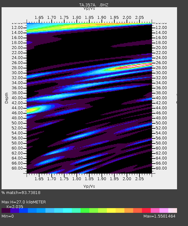
| Estimated Moho Depth: |
27.0 km |
| Estimated Crust Vp/Vs: |
2.04 |
| Assumed Crust Vp: |
5.989 km/s |
| Estimated Crust Vs: |
2.943 km/s |
| Estimated Crust Poisson's Ratio: |
0.34 |
|
| Radial Match: |
93.73818 % |
| Radial Bump: |
400 |
| Transverse Match: |
90.16278 % |
| Transverse Bump: |
400 |
| SOD ConfigId: |
512894 |
| Insert Time: |
2013-09-13 11:33:22.296 +0000 |
| GWidth: |
2.5 |
| Max Bumps: |
400 |
| Tol: |
0.001 |
|
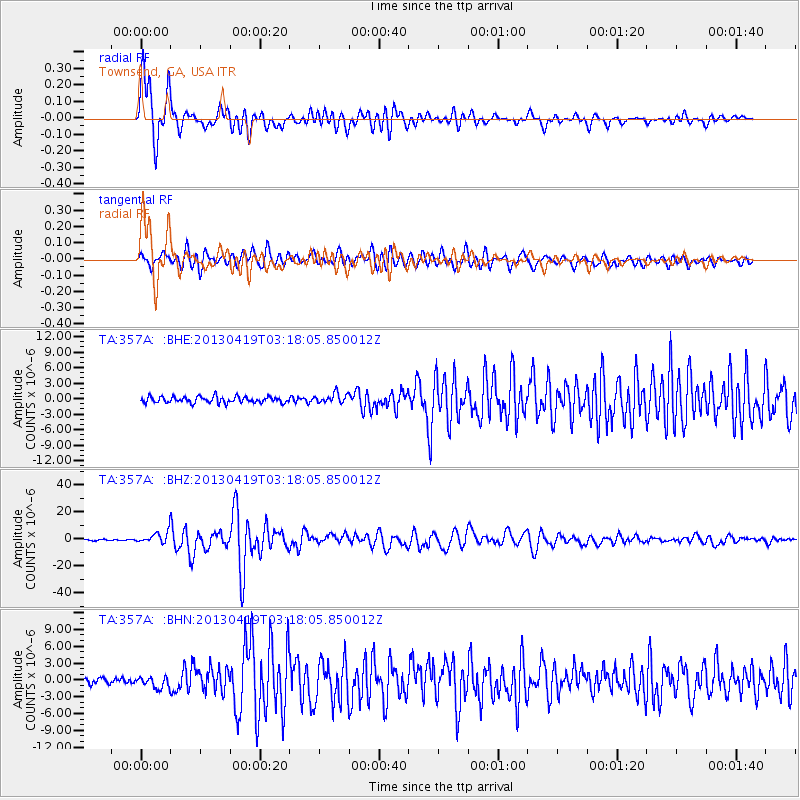
Signal To Noise
| Channel | StoN | STA | LTA |
| TA:357A: :BHZ:20130419T03:18:05.850012Z | 10.807474 | 4.3263963E-6 | 4.003152E-7 |
| TA:357A: :BHN:20130419T03:18:05.850012Z | 1.740249 | 9.842374E-7 | 5.6557275E-7 |
| TA:357A: :BHE:20130419T03:18:05.850012Z | 1.5809381 | 9.53978E-7 | 6.0342524E-7 |
| Arrivals |
| Ps | 4.7 SECOND |
| PpPs | 13 SECOND |
| PsPs/PpSs | 18 SECOND |


