You are here: Home > Network List > TA - USArray Transportable Network (new EarthScope stations) Stations List
> Station 435B Jarrell, TX, USA > Earthquake Result Viewer
435B Jarrell, TX, USA - Earthquake Result Viewer
| Earthquake location: |
Kuril Islands |
| Earthquake latitude/longitude: |
46.2/150.8 |
| Earthquake time(UTC): |
2013/04/19 (109) 03:05:52 GMT |
| Earthquake Depth: |
110 km |
| Earthquake Magnitude: |
7.2 MW, 7.1 MB, 7.2 MW |
| Earthquake Catalog/Contributor: |
NEIC PDE/NEIC PDE-W |
|
| Network: |
TA USArray Transportable Network (new EarthScope stations) |
| Station: |
435B Jarrell, TX, USA |
| Lat/Lon: |
30.78 N/97.58 W |
| Elevation: |
248 m |
|
| Distance: |
81.6 deg |
| Az: |
53.972 deg |
| Baz: |
319.274 deg |
| Ray Param: |
0.047231987 |
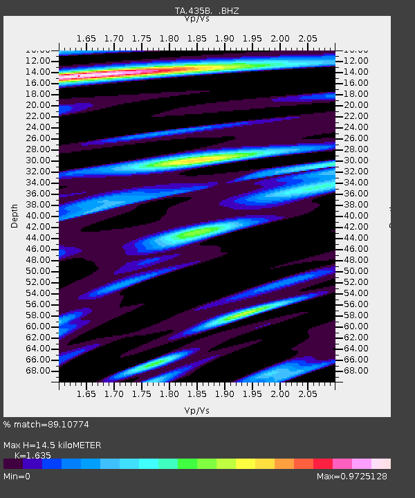
| Estimated Moho Depth: |
14.5 km |
| Estimated Crust Vp/Vs: |
1.63 |
| Assumed Crust Vp: |
6.347 km/s |
| Estimated Crust Vs: |
3.882 km/s |
| Estimated Crust Poisson's Ratio: |
0.20 |
|
| Radial Match: |
89.10774 % |
| Radial Bump: |
400 |
| Transverse Match: |
81.882576 % |
| Transverse Bump: |
400 |
| SOD ConfigId: |
512894 |
| Insert Time: |
2013-09-13 11:33:24.515 +0000 |
| GWidth: |
2.5 |
| Max Bumps: |
400 |
| Tol: |
0.001 |
|

Signal To Noise
| Channel | StoN | STA | LTA |
| TA:435B: :BHZ:20130419T03:17:27.225012Z | 23.598963 | 3.5458797E-6 | 1.5025576E-7 |
| TA:435B: :BHN:20130419T03:17:27.225012Z | 5.912165 | 1.1974569E-6 | 2.0254117E-7 |
| TA:435B: :BHE:20130419T03:17:27.225012Z | 5.1301184 | 8.420661E-7 | 1.6414164E-7 |
| Arrivals |
| Ps | 1.5 SECOND |
| PpPs | 5.9 SECOND |
| PsPs/PpSs | 7.3 SECOND |


