You are here: Home > Network List > TA - USArray Transportable Network (new EarthScope stations) Stations List
> Station 452A Marianna, FL, USA > Earthquake Result Viewer
452A Marianna, FL, USA - Earthquake Result Viewer
| Earthquake location: |
Kuril Islands |
| Earthquake latitude/longitude: |
46.2/150.8 |
| Earthquake time(UTC): |
2013/04/19 (109) 03:05:52 GMT |
| Earthquake Depth: |
110 km |
| Earthquake Magnitude: |
7.2 MW, 7.1 MB, 7.2 MW |
| Earthquake Catalog/Contributor: |
NEIC PDE/NEIC PDE-W |
|
| Network: |
TA USArray Transportable Network (new EarthScope stations) |
| Station: |
452A Marianna, FL, USA |
| Lat/Lon: |
30.85 N/85.18 W |
| Elevation: |
35 m |
|
| Distance: |
88.1 deg |
| Az: |
45.491 deg |
| Baz: |
324.85 deg |
| Ray Param: |
0.04260017 |
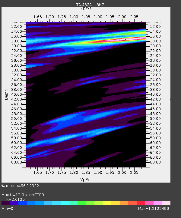
| Estimated Moho Depth: |
17.0 km |
| Estimated Crust Vp/Vs: |
2.01 |
| Assumed Crust Vp: |
6.347 km/s |
| Estimated Crust Vs: |
3.154 km/s |
| Estimated Crust Poisson's Ratio: |
0.34 |
|
| Radial Match: |
96.12322 % |
| Radial Bump: |
400 |
| Transverse Match: |
92.80554 % |
| Transverse Bump: |
400 |
| SOD ConfigId: |
512894 |
| Insert Time: |
2013-09-13 11:33:36.822 +0000 |
| GWidth: |
2.5 |
| Max Bumps: |
400 |
| Tol: |
0.001 |
|

Signal To Noise
| Channel | StoN | STA | LTA |
| TA:452A: :BHZ:20130419T03:17:59.725012Z | 11.268951 | 5.487616E-6 | 4.8696774E-7 |
| TA:452A: :BHN:20130419T03:17:59.725012Z | 2.3572943 | 8.007072E-7 | 3.3967214E-7 |
| TA:452A: :BHE:20130419T03:17:59.725012Z | 1.4273472 | 5.08286E-7 | 3.561054E-7 |
| Arrivals |
| Ps | 2.8 SECOND |
| PpPs | 7.9 SECOND |
| PsPs/PpSs | 11 SECOND |


