You are here: Home > Network List > TA - USArray Transportable Network (new EarthScope stations) Stations List
> Station 453A Whigham, GA, USA > Earthquake Result Viewer
453A Whigham, GA, USA - Earthquake Result Viewer
| Earthquake location: |
Kuril Islands |
| Earthquake latitude/longitude: |
46.2/150.8 |
| Earthquake time(UTC): |
2013/04/19 (109) 03:05:52 GMT |
| Earthquake Depth: |
110 km |
| Earthquake Magnitude: |
7.2 MW, 7.1 MB, 7.2 MW |
| Earthquake Catalog/Contributor: |
NEIC PDE/NEIC PDE-W |
|
| Network: |
TA USArray Transportable Network (new EarthScope stations) |
| Station: |
453A Whigham, GA, USA |
| Lat/Lon: |
30.85 N/84.32 W |
| Elevation: |
82 m |
|
| Distance: |
88.5 deg |
| Az: |
44.88 deg |
| Baz: |
325.273 deg |
| Ray Param: |
0.04228782 |
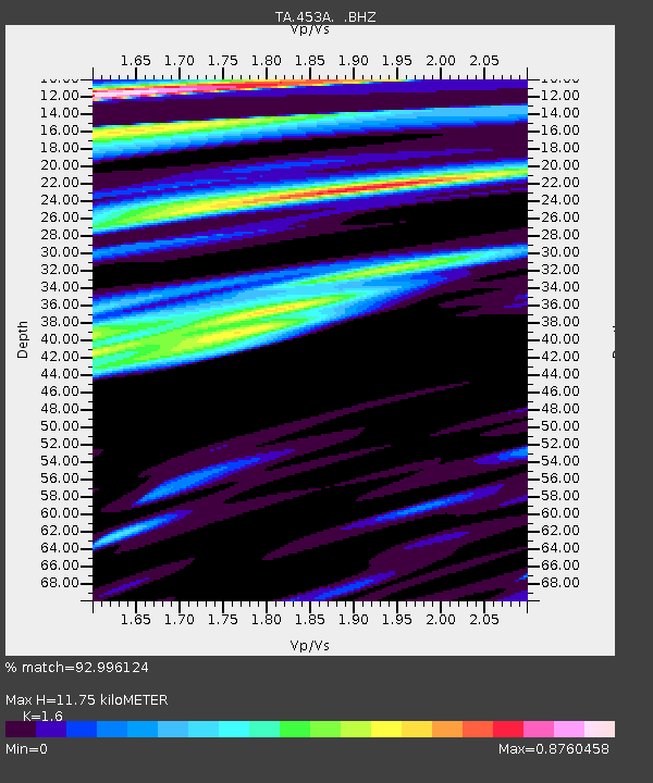
| Estimated Moho Depth: |
11.75 km |
| Estimated Crust Vp/Vs: |
1.60 |
| Assumed Crust Vp: |
6.347 km/s |
| Estimated Crust Vs: |
3.967 km/s |
| Estimated Crust Poisson's Ratio: |
0.18 |
|
| Radial Match: |
92.996124 % |
| Radial Bump: |
400 |
| Transverse Match: |
93.310295 % |
| Transverse Bump: |
400 |
| SOD ConfigId: |
512894 |
| Insert Time: |
2013-09-13 11:33:39.558 +0000 |
| GWidth: |
2.5 |
| Max Bumps: |
400 |
| Tol: |
0.001 |
|
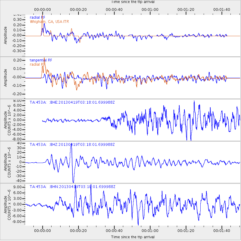
Signal To Noise
| Channel | StoN | STA | LTA |
| TA:453A: :BHZ:20130419T03:18:01.699988Z | 12.293505 | 3.9041593E-6 | 3.1757904E-7 |
| TA:453A: :BHN:20130419T03:18:01.699988Z | 1.6539664 | 7.1569656E-7 | 4.327153E-7 |
| TA:453A: :BHE:20130419T03:18:01.699988Z | 1.838061 | 6.082242E-7 | 3.3090532E-7 |
| Arrivals |
| Ps | 1.1 SECOND |
| PpPs | 4.7 SECOND |
| PsPs/PpSs | 5.8 SECOND |


