You are here: Home > Network List > TA - USArray Transportable Network (new EarthScope stations) Stations List
> Station 455A Stateville, GA, USA > Earthquake Result Viewer
455A Stateville, GA, USA - Earthquake Result Viewer
| Earthquake location: |
Kuril Islands |
| Earthquake latitude/longitude: |
46.2/150.8 |
| Earthquake time(UTC): |
2013/04/19 (109) 03:05:52 GMT |
| Earthquake Depth: |
110 km |
| Earthquake Magnitude: |
7.2 MW, 7.1 MB, 7.2 MW |
| Earthquake Catalog/Contributor: |
NEIC PDE/NEIC PDE-W |
|
| Network: |
TA USArray Transportable Network (new EarthScope stations) |
| Station: |
455A Stateville, GA, USA |
| Lat/Lon: |
30.74 N/83.03 W |
| Elevation: |
44 m |
|
| Distance: |
89.2 deg |
| Az: |
44.024 deg |
| Baz: |
325.915 deg |
| Ray Param: |
0.041764714 |
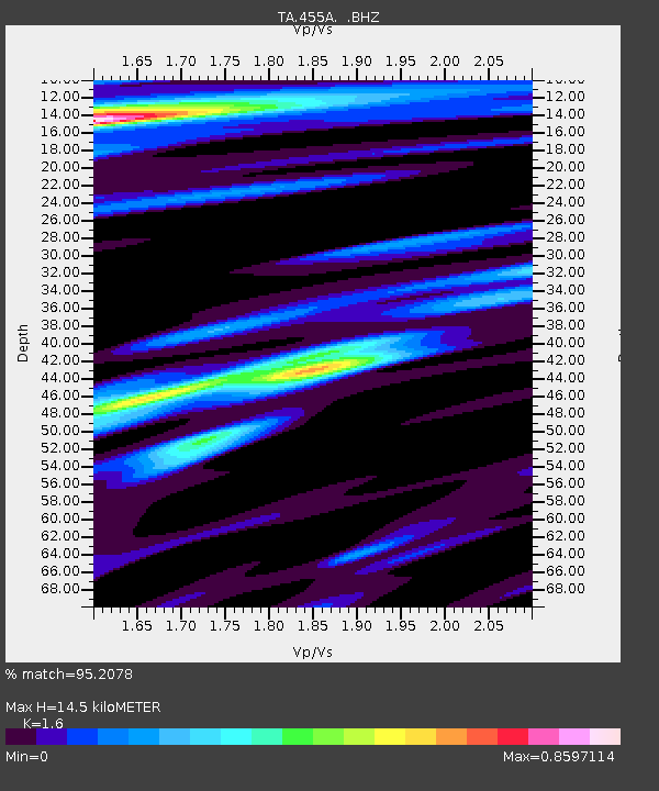
| Estimated Moho Depth: |
14.5 km |
| Estimated Crust Vp/Vs: |
1.60 |
| Assumed Crust Vp: |
6.565 km/s |
| Estimated Crust Vs: |
4.103 km/s |
| Estimated Crust Poisson's Ratio: |
0.18 |
|
| Radial Match: |
95.2078 % |
| Radial Bump: |
399 |
| Transverse Match: |
91.356476 % |
| Transverse Bump: |
400 |
| SOD ConfigId: |
512894 |
| Insert Time: |
2013-09-13 11:33:46.064 +0000 |
| GWidth: |
2.5 |
| Max Bumps: |
400 |
| Tol: |
0.001 |
|

Signal To Noise
| Channel | StoN | STA | LTA |
| TA:455A: :BHZ:20130419T03:18:05.074988Z | 21.58066 | 4.5770716E-6 | 2.1209138E-7 |
| TA:455A: :BHN:20130419T03:18:05.074988Z | 4.5632544 | 8.426646E-7 | 1.8466308E-7 |
| TA:455A: :BHE:20130419T03:18:05.074988Z | 2.1500204 | 6.0264404E-7 | 2.802969E-7 |
| Arrivals |
| Ps | 1.4 SECOND |
| PpPs | 5.6 SECOND |
| PsPs/PpSs | 7.0 SECOND |


