You are here: Home > Network List > TA - USArray Transportable Network (new EarthScope stations) Stations List
> Station 757A Oxford, FL, USA > Earthquake Result Viewer
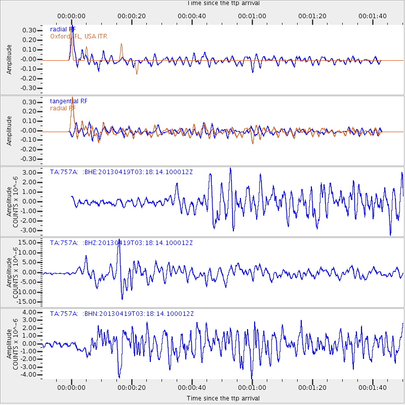
757A Oxford, FL, USA - Earthquake Result Viewer

| Earthquake location: |
Kuril Islands |
| Earthquake latitude/longitude: |
46.2/150.8 |
| Earthquake time(UTC): |
2013/04/19 (109) 03:05:52 GMT |
| Earthquake Depth: |
110 km |
| Earthquake Magnitude: |
7.2 MW, 7.1 MB, 7.2 MW |
| Earthquake Catalog/Contributor: |
NEIC PDE/NEIC PDE-W |
|
| Network: |
TA USArray Transportable Network (new EarthScope stations) |
| Station: |
757A Oxford, FL, USA |
| Lat/Lon: |
28.94 N/82.07 W |
| Elevation: |
22 m |
|
| Distance: |
91.2 deg |
| Az: |
44.333 deg |
| Baz: |
326.388 deg |
| Ray Param: |
0.041597083 |
| Estimated Moho Depth: |
21.75 km |
| Estimated Crust Vp/Vs: |
1.98 |
| Assumed Crust Vp: |
5.989 km/s |
| Estimated Crust Vs: |
3.025 km/s |
| Estimated Crust Poisson's Ratio: |
0.33 |
|
| Radial Match: |
94.133514 % |
| Radial Bump: |
392 |
| Transverse Match: |
86.835915 % |
| Transverse Bump: |
400 |
| SOD ConfigId: |
512894 |
| Insert Time: |
2013-09-13 11:34:26.297 +0000 |
| GWidth: |
2.5 |
| Max Bumps: |
400 |
| Tol: |
0.001 |
|
Signal To Noise
| Channel | StoN | STA | LTA |
| TA:757A: :BHZ:20130419T03:18:14.100012Z | 10.658573 | 2.5812142E-6 | 2.4217258E-7 |
| TA:757A: :BHN:20130419T03:18:14.100012Z | 2.0211496 | 5.008899E-7 | 2.4782423E-7 |
| TA:757A: :BHE:20130419T03:18:14.100012Z | 2.051754 | 5.183929E-7 | 2.526584E-7 |
| Arrivals |
| Ps | 3.6 SECOND |
| PpPs | 11 SECOND |
| PsPs/PpSs | 14 SECOND |


