You are here: Home > Network List > 1U - Mt. Paektu Seismic Network Stations List
> Station PDBD Paektu Bridge > Earthquake Result Viewer
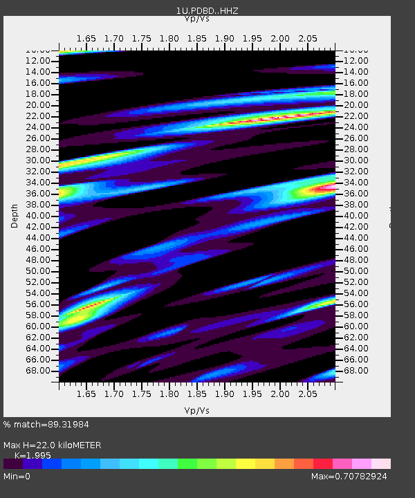
PDBD Paektu Bridge - Earthquake Result Viewer
| Earthquake location: |
Fiji Islands Region |
| Earthquake latitude/longitude: |
-19.8/-178.4 |
| Earthquake time(UTC): |
2014/07/21 (202) 14:54:40 GMT |
| Earthquake Depth: |
616 km |
| Earthquake Magnitude: |
6.9 MWB, 6.9 MI |
| Earthquake Catalog/Contributor: |
NEIC PDE/NEIC ALERT |
|
| Network: |
1U Mt. Paektu Seismic Network |
| Station: |
PDBD Paektu Bridge |
| Lat/Lon: |
41.99 N/128.13 E |
| Elevation: |
2164 m |
|
| Distance: |
78.8 deg |
| Az: |
322.383 deg |
| Baz: |
129.555 deg |
| Ray Param: |
0.04744437 |
| Estimated Moho Depth: |
22.0 km |
| Estimated Crust Vp/Vs: |
2.00 |
| Assumed Crust Vp: |
6.472 km/s |
| Estimated Crust Vs: |
3.244 km/s |
| Estimated Crust Poisson's Ratio: |
0.33 |
|
| Radial Match: |
89.31984 % |
| Radial Bump: |
278 |
| Transverse Match: |
78.44147 % |
| Transverse Bump: |
400 |
| SOD ConfigId: |
3390531 |
| Insert Time: |
2019-04-12 23:40:43.178 +0000 |
| GWidth: |
2.5 |
| Max Bumps: |
400 |
| Tol: |
0.001 |
|

Signal To Noise
| Channel | StoN | STA | LTA |
| 1U:PDBD: :HHZ:20140721T15:05:10.66001Z | 46.759342 | 6.979161E-6 | 1.4925703E-7 |
| 1U:PDBD: :HHN:20140721T15:05:10.66001Z | 6.81439 | 2.4749643E-6 | 3.6319676E-7 |
| 1U:PDBD: :HHE:20140721T15:05:10.66001Z | 9.910846 | 2.3662242E-6 | 2.3875097E-7 |
| Arrivals |
| Ps | 3.5 SECOND |
| PpPs | 9.9 SECOND |
| PsPs/PpSs | 13 SECOND |


