You are here: Home > Network List > 1U - Mt. Paektu Seismic Network Stations List
> Station SMSD Sin Mu Song > Earthquake Result Viewer
SMSD Sin Mu Song - Earthquake Result Viewer
| Earthquake location: |
Fiji Islands Region |
| Earthquake latitude/longitude: |
-19.8/-178.4 |
| Earthquake time(UTC): |
2014/07/21 (202) 14:54:40 GMT |
| Earthquake Depth: |
616 km |
| Earthquake Magnitude: |
6.9 MWB, 6.9 MI |
| Earthquake Catalog/Contributor: |
NEIC PDE/NEIC ALERT |
|
| Network: |
1U Mt. Paektu Seismic Network |
| Station: |
SMSD Sin Mu Song |
| Lat/Lon: |
41.97 N/128.32 E |
| Elevation: |
1443 m |
|
| Distance: |
78.7 deg |
| Az: |
322.46 deg |
| Baz: |
129.698 deg |
| Ray Param: |
0.047527097 |
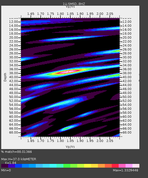
| Estimated Moho Depth: |
37.0 km |
| Estimated Crust Vp/Vs: |
1.84 |
| Assumed Crust Vp: |
6.472 km/s |
| Estimated Crust Vs: |
3.517 km/s |
| Estimated Crust Poisson's Ratio: |
0.29 |
|
| Radial Match: |
88.01366 % |
| Radial Bump: |
400 |
| Transverse Match: |
83.230095 % |
| Transverse Bump: |
400 |
| SOD ConfigId: |
3390531 |
| Insert Time: |
2019-04-12 23:40:43.737 +0000 |
| GWidth: |
2.5 |
| Max Bumps: |
400 |
| Tol: |
0.001 |
|

Signal To Noise
| Channel | StoN | STA | LTA |
| 1U:SMSD: :BHZ:20140721T15:05:10.019995Z | 44.61586 | 7.889886E-6 | 1.7684039E-7 |
| 1U:SMSD: :BHN:20140721T15:05:10.019995Z | 5.9128833 | 1.316569E-6 | 2.2266107E-7 |
| 1U:SMSD: :BHE:20140721T15:05:10.019995Z | 9.714033 | 2.7738051E-6 | 2.8554618E-7 |
| Arrivals |
| Ps | 4.9 SECOND |
| PpPs | 16 SECOND |
| PsPs/PpSs | 21 SECOND |


