You are here: Home > Network List > TA - USArray Transportable Network (new EarthScope stations) Stations List
> Station 958A Wauchula, FL, USA > Earthquake Result Viewer
958A Wauchula, FL, USA - Earthquake Result Viewer
| Earthquake location: |
Kuril Islands |
| Earthquake latitude/longitude: |
46.2/150.8 |
| Earthquake time(UTC): |
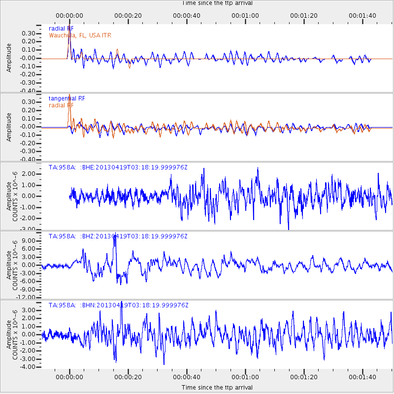
2013/04/19 (109) 03:05:52 GMT |
| Earthquake Depth: |
110 km |
| Earthquake Magnitude: |
7.2 MW, 7.1 MB, 7.2 MW |
| Earthquake Catalog/Contributor: |
NEIC PDE/NEIC PDE-W |
|
| Network: |
TA USArray Transportable Network (new EarthScope stations) |
| Station: |
958A Wauchula, FL, USA |
| Lat/Lon: |
27.59 N/81.75 W |
| Elevation: |
30 m |
|
| Distance: |
92.5 deg |
| Az: |
44.848 deg |
| Baz: |
326.52 deg |
| Ray Param: |
0.041389875 |
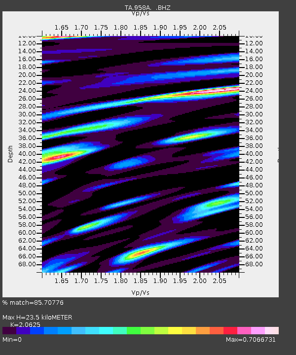
| Estimated Moho Depth: |
23.5 km |
| Estimated Crust Vp/Vs: |
2.06 |
| Assumed Crust Vp: |
6.347 km/s |
| Estimated Crust Vs: |
3.077 km/s |
| Estimated Crust Poisson's Ratio: |
0.35 |
|
| Radial Match: |
85.70776 % |
| Radial Bump: |
400 |
| Transverse Match: |
76.68533 % |
| Transverse Bump: |
400 |
| SOD ConfigId: |
512894 |
| Insert Time: |
2013-09-13 11:34:53.574 +0000 |
| GWidth: |
2.5 |
| Max Bumps: |
400 |
| Tol: |
0.001 |
|
Signal To Noise
| Channel | StoN | STA | LTA |
| TA:958A: :BHZ:20130419T03:18:19.999976Z | 4.6746993 | 2.089943E-6 | 4.470754E-7 |
| TA:958A: :BHN:20130419T03:18:19.999976Z | 1.6682928 | 6.5396966E-7 | 3.9199938E-7 |
| TA:958A: :BHE:20130419T03:18:19.999976Z | 1.5033177 | 6.086014E-7 | 4.0483883E-7 |
| Arrivals |
| Ps | 4.0 SECOND |
| PpPs | 11 SECOND |
| PsPs/PpSs | 15 SECOND |


