You are here: Home > Network List > TA - USArray Transportable Network (new EarthScope stations) Stations List
> Station D03D Eldon, WA, USA > Earthquake Result Viewer
D03D Eldon, WA, USA - Earthquake Result Viewer
| Earthquake location: |
Kuril Islands |
| Earthquake latitude/longitude: |
46.2/150.8 |
| Earthquake time(UTC): |
2013/04/19 (109) 03:05:52 GMT |
| Earthquake Depth: |
110 km |
| Earthquake Magnitude: |
7.2 MW, 7.1 MB, 7.2 MW |
| Earthquake Catalog/Contributor: |
NEIC PDE/NEIC PDE-W |
|
| Network: |
TA USArray Transportable Network (new EarthScope stations) |
| Station: |
D03D Eldon, WA, USA |
| Lat/Lon: |
47.53 N/123.09 W |
| Elevation: |
262 m |
|
| Distance: |
55.9 deg |
| Az: |
54.759 deg |
| Baz: |
303.191 deg |
| Ray Param: |
0.06417621 |
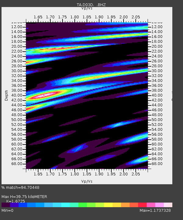
| Estimated Moho Depth: |
39.75 km |
| Estimated Crust Vp/Vs: |
1.67 |
| Assumed Crust Vp: |
6.566 km/s |
| Estimated Crust Vs: |
3.926 km/s |
| Estimated Crust Poisson's Ratio: |
0.22 |
|
| Radial Match: |
94.70448 % |
| Radial Bump: |
400 |
| Transverse Match: |
93.896385 % |
| Transverse Bump: |
400 |
| SOD ConfigId: |
512894 |
| Insert Time: |
2013-09-13 11:35:26.571 +0000 |
| GWidth: |
2.5 |
| Max Bumps: |
400 |
| Tol: |
0.001 |
|

Signal To Noise
| Channel | StoN | STA | LTA |
| TA:D03D: :BHZ:20130419T03:14:48.223975Z | 30.610874 | 3.974188E-6 | 1.2982929E-7 |
| TA:D03D: :BHN:20130419T03:14:48.223975Z | 8.16408 | 1.0482926E-6 | 1.2840302E-7 |
| TA:D03D: :BHE:20130419T03:14:48.223975Z | 19.51436 | 1.5493636E-6 | 7.9396074E-8 |
| Arrivals |
| Ps | 4.3 SECOND |
| PpPs | 15 SECOND |
| PsPs/PpSs | 20 SECOND |


