You are here: Home > Network List > TA - USArray Transportable Network (new EarthScope stations) Stations List
> Station D52A ZEK Kipawa Senerzegues Township, QC, CAN > Earthquake Result Viewer
D52A ZEK Kipawa Senerzegues Township, QC, CAN - Earthquake Result Viewer
| Earthquake location: |
Kuril Islands |
| Earthquake latitude/longitude: |
46.2/150.8 |
| Earthquake time(UTC): |
2013/04/19 (109) 03:05:52 GMT |
| Earthquake Depth: |
110 km |
| Earthquake Magnitude: |
7.2 MW, 7.1 MB, 7.2 MW |
| Earthquake Catalog/Contributor: |
NEIC PDE/NEIC PDE-W |
|
| Network: |
TA USArray Transportable Network (new EarthScope stations) |
| Station: |
D52A ZEK Kipawa Senerzegues Township, QC, CAN |
| Lat/Lon: |
46.98 N/78.41 W |
| Elevation: |
359 m |
|
| Distance: |
77.7 deg |
| Az: |
32.047 deg |
| Baz: |
327.451 deg |
| Ray Param: |
0.049919773 |
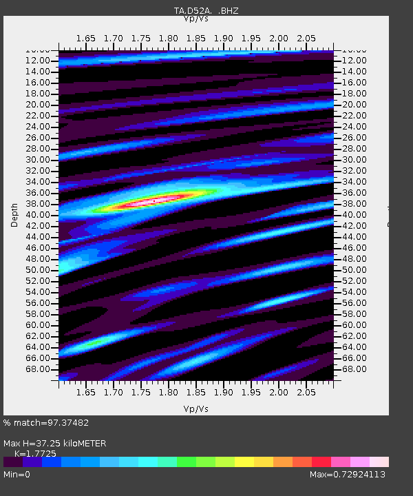
| Estimated Moho Depth: |
37.25 km |
| Estimated Crust Vp/Vs: |
1.77 |
| Assumed Crust Vp: |
6.622 km/s |
| Estimated Crust Vs: |
3.736 km/s |
| Estimated Crust Poisson's Ratio: |
0.27 |
|
| Radial Match: |
97.37482 % |
| Radial Bump: |
390 |
| Transverse Match: |
90.75086 % |
| Transverse Bump: |
400 |
| SOD ConfigId: |
512894 |
| Insert Time: |
2013-09-13 11:35:48.942 +0000 |
| GWidth: |
2.5 |
| Max Bumps: |
400 |
| Tol: |
0.001 |
|
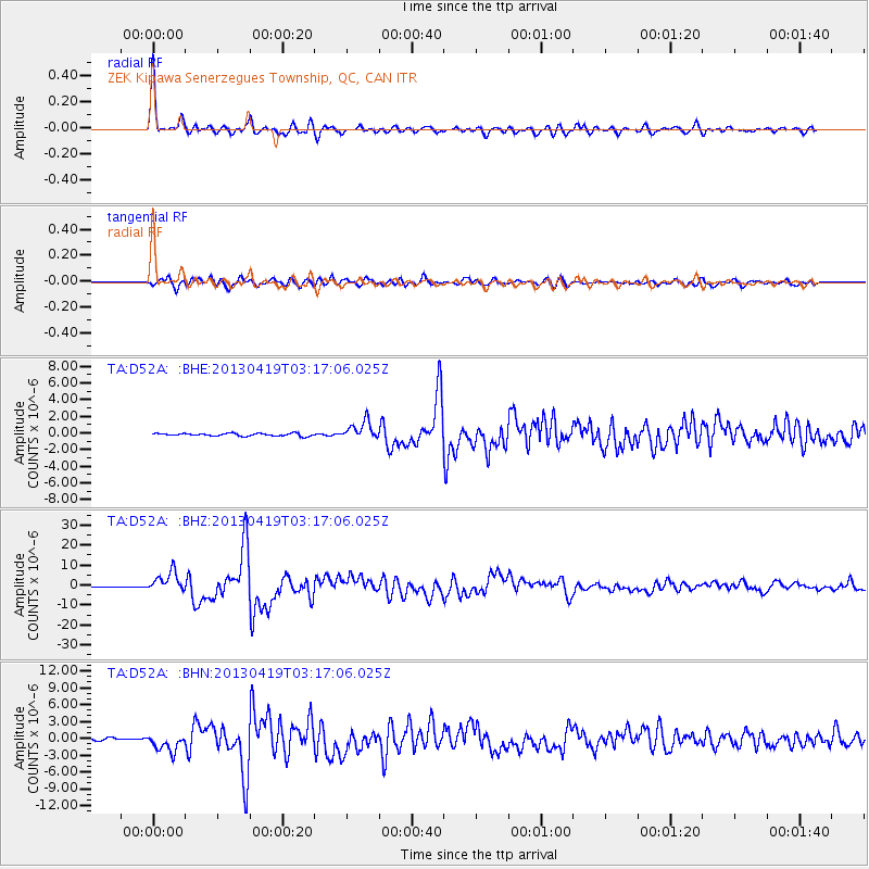
Signal To Noise
| Channel | StoN | STA | LTA |
| TA:D52A: :BHZ:20130419T03:17:06.025Z | 16.432026 | 5.046672E-6 | 3.0712414E-7 |
| TA:D52A: :BHN:20130419T03:17:06.025Z | 10.243647 | 1.5855181E-6 | 1.5478064E-7 |
| TA:D52A: :BHE:20130419T03:17:06.025Z | 7.04707 | 1.0867843E-6 | 1.542179E-7 |
| Arrivals |
| Ps | 4.5 SECOND |
| PpPs | 15 SECOND |
| PsPs/PpSs | 20 SECOND |


