You are here: Home > Network List > TA - USArray Transportable Network (new EarthScope stations) Stations List
> Station E47A Iron Bridge, ON, CAN > Earthquake Result Viewer
E47A Iron Bridge, ON, CAN - Earthquake Result Viewer
| Earthquake location: |
Kuril Islands |
| Earthquake latitude/longitude: |
46.2/150.8 |
| Earthquake time(UTC): |
2013/04/19 (109) 03:05:52 GMT |
| Earthquake Depth: |
110 km |
| Earthquake Magnitude: |
7.2 MW, 7.1 MB, 7.2 MW |
| Earthquake Catalog/Contributor: |
NEIC PDE/NEIC PDE-W |
|
| Network: |
TA USArray Transportable Network (new EarthScope stations) |
| Station: |
E47A Iron Bridge, ON, CAN |
| Lat/Lon: |
46.45 N/83.28 W |
| Elevation: |
246 m |
|
| Distance: |
76.2 deg |
| Az: |
35.197 deg |
| Baz: |
324.631 deg |
| Ray Param: |
0.050885182 |
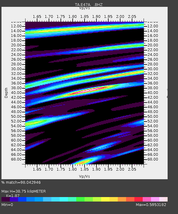
| Estimated Moho Depth: |
38.75 km |
| Estimated Crust Vp/Vs: |
1.87 |
| Assumed Crust Vp: |
6.467 km/s |
| Estimated Crust Vs: |
3.458 km/s |
| Estimated Crust Poisson's Ratio: |
0.30 |
|
| Radial Match: |
98.042946 % |
| Radial Bump: |
244 |
| Transverse Match: |
91.9411 % |
| Transverse Bump: |
392 |
| SOD ConfigId: |
512894 |
| Insert Time: |
2013-09-13 11:36:33.333 +0000 |
| GWidth: |
2.5 |
| Max Bumps: |
400 |
| Tol: |
0.001 |
|
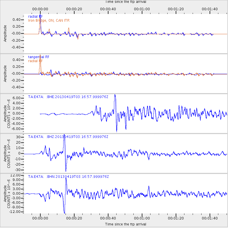
Signal To Noise
| Channel | StoN | STA | LTA |
| TA:E47A: :BHZ:20130419T03:16:57.999976Z | 26.728327 | 5.1457314E-6 | 1.9251976E-7 |
| TA:E47A: :BHN:20130419T03:16:57.999976Z | 10.532756 | 1.7846199E-6 | 1.6943522E-7 |
| TA:E47A: :BHE:20130419T03:16:57.999976Z | 8.048429 | 1.1753494E-6 | 1.4603465E-7 |
| Arrivals |
| Ps | 5.4 SECOND |
| PpPs | 17 SECOND |
| PsPs/PpSs | 22 SECOND |


