You are here: Home > Network List > TA - USArray Transportable Network (new EarthScope stations) Stations List
> Station F45A CMU Biological Station, Beaver Island, MI, USA > Earthquake Result Viewer
F45A CMU Biological Station, Beaver Island, MI, USA - Earthquake Result Viewer
| Earthquake location: |
Kuril Islands |
| Earthquake latitude/longitude: |
46.2/150.8 |
| Earthquake time(UTC): |
2013/04/19 (109) 03:05:52 GMT |
| Earthquake Depth: |
110 km |
| Earthquake Magnitude: |
7.2 MW, 7.1 MB, 7.2 MW |
| Earthquake Catalog/Contributor: |
NEIC PDE/NEIC PDE-W |
|
| Network: |
TA USArray Transportable Network (new EarthScope stations) |
| Station: |
F45A CMU Biological Station, Beaver Island, MI, USA |
| Lat/Lon: |
45.68 N/85.52 W |
| Elevation: |
173 m |
|
| Distance: |
75.9 deg |
| Az: |
36.963 deg |
| Baz: |
323.45 deg |
| Ray Param: |
0.051079348 |
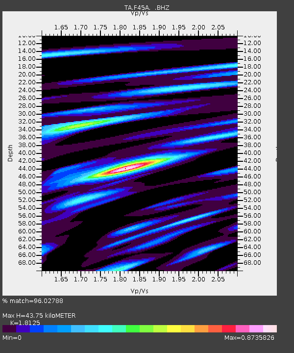
| Estimated Moho Depth: |
43.75 km |
| Estimated Crust Vp/Vs: |
1.81 |
| Assumed Crust Vp: |
6.483 km/s |
| Estimated Crust Vs: |
3.577 km/s |
| Estimated Crust Poisson's Ratio: |
0.28 |
|
| Radial Match: |
96.02788 % |
| Radial Bump: |
400 |
| Transverse Match: |
89.50318 % |
| Transverse Bump: |
400 |
| SOD ConfigId: |
512894 |
| Insert Time: |
2013-09-13 11:37:29.064 +0000 |
| GWidth: |
2.5 |
| Max Bumps: |
400 |
| Tol: |
0.001 |
|

Signal To Noise
| Channel | StoN | STA | LTA |
| TA:F45A: :BHZ:20130419T03:16:56.350012Z | 30.601229 | 5.6631184E-6 | 1.8506181E-7 |
| TA:F45A: :BHN:20130419T03:16:56.350012Z | 10.707808 | 2.291864E-6 | 2.140367E-7 |
| TA:F45A: :BHE:20130419T03:16:56.350012Z | 5.526994 | 1.4481489E-6 | 2.6201383E-7 |
| Arrivals |
| Ps | 5.7 SECOND |
| PpPs | 18 SECOND |
| PsPs/PpSs | 24 SECOND |


