You are here: Home > Network List > TA - USArray Transportable Network (new EarthScope stations) Stations List
> Station F51A Arnstein, ON, CAN > Earthquake Result Viewer
F51A Arnstein, ON, CAN - Earthquake Result Viewer

| Earthquake location: |
Kuril Islands |
| Earthquake latitude/longitude: |
46.2/150.8 |
| Earthquake time(UTC): |
2013/04/19 (109) 03:05:52 GMT |
| Earthquake Depth: |
110 km |
| Earthquake Magnitude: |
7.2 MW, 7.1 MB, 7.2 MW |
| Earthquake Catalog/Contributor: |
NEIC PDE/NEIC PDE-W |
|
| Network: |
TA USArray Transportable Network (new EarthScope stations) |
| Station: |
F51A Arnstein, ON, CAN |
| Lat/Lon: |
45.93 N/79.92 W |
| Elevation: |
239 m |
|
| Distance: |
78.0 deg |
| Az: |
33.523 deg |
| Baz: |
326.676 deg |
| Ray Param: |
0.04970672 |
| Estimated Moho Depth: |
29.75 km |
| Estimated Crust Vp/Vs: |
1.92 |
| Assumed Crust Vp: |
6.577 km/s |
| Estimated Crust Vs: |
3.417 km/s |
| Estimated Crust Poisson's Ratio: |
0.32 |
|
| Radial Match: |
90.949356 % |
| Radial Bump: |
400 |
| Transverse Match: |
77.61054 % |
| Transverse Bump: |
400 |
| SOD ConfigId: |
512894 |
| Insert Time: |
2013-09-13 11:37:40.093 +0000 |
| GWidth: |
2.5 |
| Max Bumps: |
400 |
| Tol: |
0.001 |
|
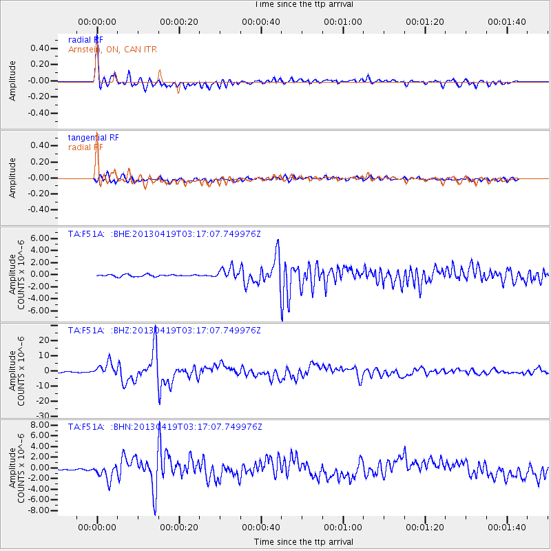
Signal To Noise
| Channel | StoN | STA | LTA |
| TA:F51A: :BHZ:20130419T03:17:07.749976Z | 18.027285 | 4.4609505E-6 | 2.474555E-7 |
| TA:F51A: :BHN:20130419T03:17:07.749976Z | 7.787754 | 1.3670692E-6 | 1.7554088E-7 |
| TA:F51A: :BHE:20130419T03:17:07.749976Z | 6.1476245 | 9.772367E-7 | 1.5896168E-7 |
| Arrivals |
| Ps | 4.3 SECOND |
| PpPs | 13 SECOND |
| PsPs/PpSs | 17 SECOND |


