You are here: Home > Network List > TA - USArray Transportable Network (new EarthScope stations) Stations List
> Station H40A Chili, WI, USA > Earthquake Result Viewer
H40A Chili, WI, USA - Earthquake Result Viewer

| Earthquake location: |
Kuril Islands |
| Earthquake latitude/longitude: |
46.2/150.8 |
| Earthquake time(UTC): |
2013/04/19 (109) 03:05:52 GMT |
| Earthquake Depth: |
110 km |
| Earthquake Magnitude: |
7.2 MW, 7.1 MB, 7.2 MW |
| Earthquake Catalog/Contributor: |
NEIC PDE/NEIC PDE-W |
|
| Network: |
TA USArray Transportable Network (new EarthScope stations) |
| Station: |
H40A Chili, WI, USA |
| Lat/Lon: |
44.62 N/90.39 W |
| Elevation: |
372 m |
|
| Distance: |
74.6 deg |
| Az: |
40.452 deg |
| Baz: |
320.89 deg |
| Ray Param: |
0.051930223 |
| Estimated Moho Depth: |
43.5 km |
| Estimated Crust Vp/Vs: |
1.87 |
| Assumed Crust Vp: |
6.571 km/s |
| Estimated Crust Vs: |
3.523 km/s |
| Estimated Crust Poisson's Ratio: |
0.30 |
|
| Radial Match: |
94.69366 % |
| Radial Bump: |
400 |
| Transverse Match: |
87.826454 % |
| Transverse Bump: |
400 |
| SOD ConfigId: |
512894 |
| Insert Time: |
2013-09-13 11:38:42.363 +0000 |
| GWidth: |
2.5 |
| Max Bumps: |
400 |
| Tol: |
0.001 |
|
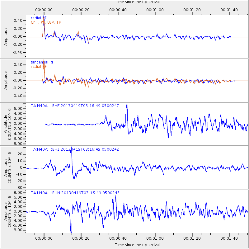
Signal To Noise
| Channel | StoN | STA | LTA |
| TA:H40A: :BHZ:20130419T03:16:49.050024Z | 15.95976 | 4.628957E-6 | 2.9003925E-7 |
| TA:H40A: :BHN:20130419T03:16:49.050024Z | 8.760647 | 1.3925155E-6 | 1.5895122E-7 |
| TA:H40A: :BHE:20130419T03:16:49.050024Z | 9.085159 | 1.2618364E-6 | 1.3888983E-7 |
| Arrivals |
| Ps | 5.9 SECOND |
| PpPs | 18 SECOND |
| PsPs/PpSs | 24 SECOND |


