You are here: Home > Network List > TO - Tectonic Observatory Stations List
> Station CC37 CCSE CC37 > Earthquake Result Viewer
CC37 CCSE CC37 - Earthquake Result Viewer
| Earthquake location: |
Fiji Islands Region |
| Earthquake latitude/longitude: |
-19.8/-178.4 |
| Earthquake time(UTC): |
2014/07/21 (202) 14:54:40 GMT |
| Earthquake Depth: |
616 km |
| Earthquake Magnitude: |
6.9 MWB, 6.9 MI |
| Earthquake Catalog/Contributor: |
NEIC PDE/NEIC ALERT |
|
| Network: |
TO Tectonic Observatory |
| Station: |
CC37 CCSE CC37 |
| Lat/Lon: |
36.39 N/118.90 W |
| Elevation: |
654 m |
|
| Distance: |
79.3 deg |
| Az: |
45.071 deg |
| Baz: |
235.716 deg |
| Ray Param: |
0.047149736 |
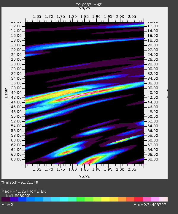
| Estimated Moho Depth: |
41.25 km |
| Estimated Crust Vp/Vs: |
1.81 |
| Assumed Crust Vp: |
6.291 km/s |
| Estimated Crust Vs: |
3.485 km/s |
| Estimated Crust Poisson's Ratio: |
0.28 |
|
| Radial Match: |
91.21149 % |
| Radial Bump: |
379 |
| Transverse Match: |
79.82821 % |
| Transverse Bump: |
400 |
| SOD ConfigId: |
3390531 |
| Insert Time: |
2019-04-12 23:44:33.591 +0000 |
| GWidth: |
2.5 |
| Max Bumps: |
400 |
| Tol: |
0.001 |
|

Signal To Noise
| Channel | StoN | STA | LTA |
| TO:CC37: :HHZ:20140721T15:05:12.699988Z | 47.004574 | 3.3577153E-6 | 7.14338E-8 |
| TO:CC37: :HHN:20140721T15:05:12.699988Z | 21.795496 | 8.802759E-7 | 4.038797E-8 |
| TO:CC37: :HHE:20140721T15:05:12.699988Z | 26.702147 | 1.3656746E-6 | 5.114475E-8 |
| Arrivals |
| Ps | 5.4 SECOND |
| PpPs | 18 SECOND |
| PsPs/PpSs | 23 SECOND |


