You are here: Home > Network List > XD14 - Illuminating the architecture of the greater Mount St. Helens magmatic systems f Stations List
> Station MB07 "Mount St Helens, WA" > Earthquake Result Viewer
MB07 "Mount St Helens, WA" - Earthquake Result Viewer
| Earthquake location: |
Fiji Islands Region |
| Earthquake latitude/longitude: |
-19.8/-178.4 |
| Earthquake time(UTC): |
2014/07/21 (202) 14:54:40 GMT |
| Earthquake Depth: |
616 km |
| Earthquake Magnitude: |
6.9 MWB, 6.9 MI |
| Earthquake Catalog/Contributor: |
NEIC PDE/NEIC ALERT |
|
| Network: |
XD Illuminating the architecture of the greater Mount St. Helens magmatic systems f |
| Station: |
MB07 "Mount St Helens, WA" |
| Lat/Lon: |
46.62 N/122.04 W |
| Elevation: |
878 m |
|
| Distance: |
83.4 deg |
| Az: |
35.304 deg |
| Baz: |
232.152 deg |
| Ray Param: |
0.04437993 |
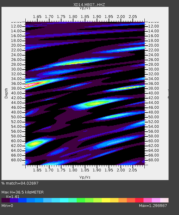
| Estimated Moho Depth: |
36.5 km |
| Estimated Crust Vp/Vs: |
1.61 |
| Assumed Crust Vp: |
6.566 km/s |
| Estimated Crust Vs: |
4.078 km/s |
| Estimated Crust Poisson's Ratio: |
0.19 |
|
| Radial Match: |
84.02697 % |
| Radial Bump: |
400 |
| Transverse Match: |
78.75372 % |
| Transverse Bump: |
400 |
| SOD ConfigId: |
3390531 |
| Insert Time: |
2019-04-12 23:45:00.442 +0000 |
| GWidth: |
2.5 |
| Max Bumps: |
400 |
| Tol: |
0.001 |
|

Signal To Noise
| Channel | StoN | STA | LTA |
| XD:MB07: :HHZ:20140721T15:05:33.665015Z | 37.57357 | 5.380168E-6 | 1.4319023E-7 |
| XD:MB07: :HHN:20140721T15:05:33.665015Z | 6.889459 | 9.541761E-7 | 1.3849798E-7 |
| XD:MB07: :HHE:20140721T15:05:33.665015Z | 7.423939 | 1.3268032E-6 | 1.7871956E-7 |
| Arrivals |
| Ps | 3.5 SECOND |
| PpPs | 14 SECOND |
| PsPs/PpSs | 18 SECOND |


