You are here: Home > Network List > XD14 - Illuminating the architecture of the greater Mount St. Helens magmatic systems f Stations List
> Station MH03 "Mount St Helens, WA" > Earthquake Result Viewer
MH03 "Mount St Helens, WA" - Earthquake Result Viewer
| Earthquake location: |
Fiji Islands Region |
| Earthquake latitude/longitude: |
-19.8/-178.4 |
| Earthquake time(UTC): |
2014/07/21 (202) 14:54:40 GMT |
| Earthquake Depth: |
616 km |
| Earthquake Magnitude: |
6.9 MWB, 6.9 MI |
| Earthquake Catalog/Contributor: |
NEIC PDE/NEIC ALERT |
|
| Network: |
XD Illuminating the architecture of the greater Mount St. Helens magmatic systems f |
| Station: |
MH03 "Mount St Helens, WA" |
| Lat/Lon: |
46.27 N/122.59 W |
| Elevation: |
373 m |
|
| Distance: |
82.9 deg |
| Az: |
35.35 deg |
| Baz: |
231.759 deg |
| Ray Param: |
0.044732995 |
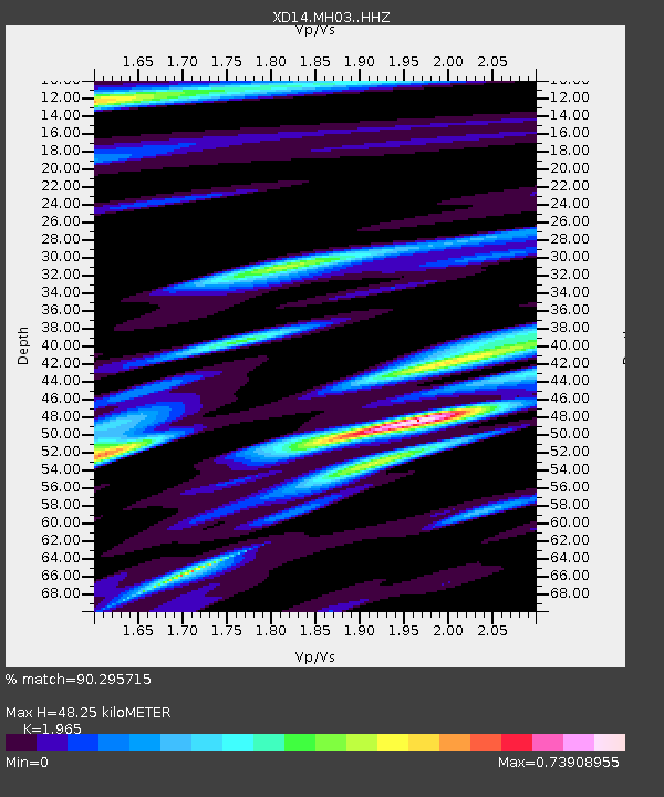
| Estimated Moho Depth: |
48.25 km |
| Estimated Crust Vp/Vs: |
1.97 |
| Assumed Crust Vp: |
6.566 km/s |
| Estimated Crust Vs: |
3.342 km/s |
| Estimated Crust Poisson's Ratio: |
0.33 |
|
| Radial Match: |
90.295715 % |
| Radial Bump: |
400 |
| Transverse Match: |
71.68516 % |
| Transverse Bump: |
400 |
| SOD ConfigId: |
3390531 |
| Insert Time: |
2019-04-12 23:45:13.947 +0000 |
| GWidth: |
2.5 |
| Max Bumps: |
400 |
| Tol: |
0.001 |
|

Signal To Noise
| Channel | StoN | STA | LTA |
| XD:MH03: :HHZ:20140721T15:05:31.095007Z | 33.89896 | 6.312446E-6 | 1.8621355E-7 |
| XD:MH03: :HHN:20140721T15:05:31.095007Z | 6.5358005 | 1.2306061E-6 | 1.8828698E-7 |
| XD:MH03: :HHE:20140721T15:05:31.095007Z | 8.326599 | 1.5595514E-6 | 1.8729752E-7 |
| Arrivals |
| Ps | 7.3 SECOND |
| PpPs | 21 SECOND |
| PsPs/PpSs | 29 SECOND |


