You are here: Home > Network List > XD14 - Illuminating the architecture of the greater Mount St. Helens magmatic systems f Stations List
> Station MH07 "Mount St Helens, WA" > Earthquake Result Viewer
MH07 "Mount St Helens, WA" - Earthquake Result Viewer
| Earthquake location: |
Fiji Islands Region |
| Earthquake latitude/longitude: |
-19.8/-178.4 |
| Earthquake time(UTC): |
2014/07/21 (202) 14:54:40 GMT |
| Earthquake Depth: |
616 km |
| Earthquake Magnitude: |
6.9 MWB, 6.9 MI |
| Earthquake Catalog/Contributor: |
NEIC PDE/NEIC ALERT |
|
| Network: |
XD Illuminating the architecture of the greater Mount St. Helens magmatic systems f |
| Station: |
MH07 "Mount St Helens, WA" |
| Lat/Lon: |
46.28 N/122.08 W |
| Elevation: |
1122 m |
|
| Distance: |
83.1 deg |
| Az: |
35.561 deg |
| Baz: |
232.154 deg |
| Ray Param: |
0.044537477 |
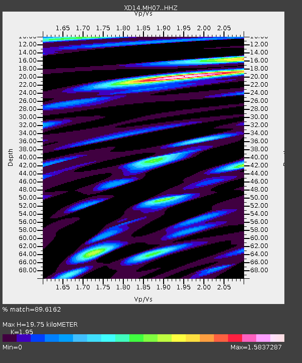
| Estimated Moho Depth: |
19.75 km |
| Estimated Crust Vp/Vs: |
1.95 |
| Assumed Crust Vp: |
6.566 km/s |
| Estimated Crust Vs: |
3.367 km/s |
| Estimated Crust Poisson's Ratio: |
0.32 |
|
| Radial Match: |
89.6162 % |
| Radial Bump: |
400 |
| Transverse Match: |
82.42019 % |
| Transverse Bump: |
400 |
| SOD ConfigId: |
3390531 |
| Insert Time: |
2019-04-12 23:45:15.236 +0000 |
| GWidth: |
2.5 |
| Max Bumps: |
400 |
| Tol: |
0.001 |
|

Signal To Noise
| Channel | StoN | STA | LTA |
| XD:MH07: :HHZ:20140721T15:05:32.509985Z | 77.21529 | 4.811091E-6 | 6.23075E-8 |
| XD:MH07: :HHN:20140721T15:05:32.509985Z | 10.451772 | 1.25884E-6 | 1.2044275E-7 |
| XD:MH07: :HHE:20140721T15:05:32.509985Z | 12.482828 | 1.4392061E-6 | 1.15294874E-7 |
| Arrivals |
| Ps | 2.9 SECOND |
| PpPs | 8.7 SECOND |
| PsPs/PpSs | 12 SECOND |


