You are here: Home > Network List > XD14 - Illuminating the architecture of the greater Mount St. Helens magmatic systems f Stations List
> Station MI02 "Mount St Helens, WA" > Earthquake Result Viewer
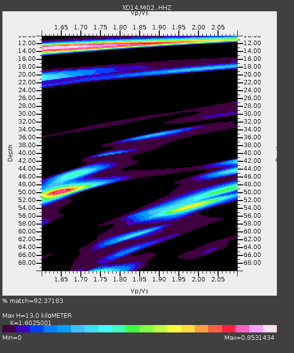
MI02 "Mount St Helens, WA" - Earthquake Result Viewer
| Earthquake location: |
Fiji Islands Region |
| Earthquake latitude/longitude: |
-19.8/-178.4 |
| Earthquake time(UTC): |
2014/07/21 (202) 14:54:40 GMT |
| Earthquake Depth: |
616 km |
| Earthquake Magnitude: |
6.9 MWB, 6.9 MI |
| Earthquake Catalog/Contributor: |
NEIC PDE/NEIC ALERT |
|
| Network: |
XD Illuminating the architecture of the greater Mount St. Helens magmatic systems f |
| Station: |
MI02 "Mount St Helens, WA" |
| Lat/Lon: |
46.22 N/122.67 W |
| Elevation: |
349 m |
|
| Distance: |
82.8 deg |
| Az: |
35.36 deg |
| Baz: |
231.709 deg |
| Ray Param: |
0.04478171 |
| Estimated Moho Depth: |
13.0 km |
| Estimated Crust Vp/Vs: |
1.60 |
| Assumed Crust Vp: |
6.566 km/s |
| Estimated Crust Vs: |
4.097 km/s |
| Estimated Crust Poisson's Ratio: |
0.18 |
|
| Radial Match: |
92.37183 % |
| Radial Bump: |
400 |
| Transverse Match: |
78.268105 % |
| Transverse Bump: |
400 |
| SOD ConfigId: |
3390531 |
| Insert Time: |
2019-04-12 23:45:17.972 +0000 |
| GWidth: |
2.5 |
| Max Bumps: |
400 |
| Tol: |
0.001 |
|

Signal To Noise
| Channel | StoN | STA | LTA |
| XD:MI02: :HHZ:20140721T15:05:30.735022Z | 38.535995 | 6.3269945E-6 | 1.6418402E-7 |
| XD:MI02: :HHN:20140721T15:05:30.735022Z | 9.722675 | 1.128377E-6 | 1.1605623E-7 |
| XD:MI02: :HHE:20140721T15:05:30.735022Z | 10.074304 | 1.2161083E-6 | 1.2071388E-7 |
| Arrivals |
| Ps | 1.2 SECOND |
| PpPs | 5.0 SECOND |
| PsPs/PpSs | 6.2 SECOND |


