You are here: Home > Network List > TA - USArray Transportable Network (new EarthScope stations) Stations List
> Station J41A Loganville, WI, USA > Earthquake Result Viewer
J41A Loganville, WI, USA - Earthquake Result Viewer
| Earthquake location: |
Kuril Islands |
| Earthquake latitude/longitude: |
46.2/150.8 |
| Earthquake time(UTC): |
2013/04/19 (109) 03:05:52 GMT |
| Earthquake Depth: |
110 km |
| Earthquake Magnitude: |
7.2 MW, 7.1 MB, 7.2 MW |
| Earthquake Catalog/Contributor: |
NEIC PDE/NEIC PDE-W |
|
| Network: |
TA USArray Transportable Network (new EarthScope stations) |
| Station: |
J41A Loganville, WI, USA |
| Lat/Lon: |
43.37 N/90.01 W |
| Elevation: |
360 m |
|
| Distance: |
75.8 deg |
| Az: |
41.049 deg |
| Baz: |
321.303 deg |
| Ray Param: |
0.051165808 |
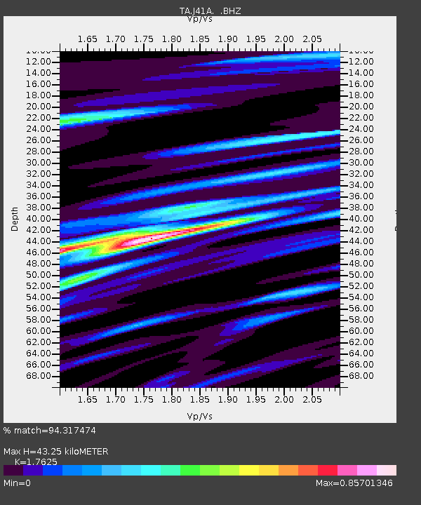
| Estimated Moho Depth: |
43.25 km |
| Estimated Crust Vp/Vs: |
1.76 |
| Assumed Crust Vp: |
6.53 km/s |
| Estimated Crust Vs: |
3.705 km/s |
| Estimated Crust Poisson's Ratio: |
0.26 |
|
| Radial Match: |
94.317474 % |
| Radial Bump: |
400 |
| Transverse Match: |
83.06637 % |
| Transverse Bump: |
400 |
| SOD ConfigId: |
512894 |
| Insert Time: |
2013-09-13 11:40:32.216 +0000 |
| GWidth: |
2.5 |
| Max Bumps: |
400 |
| Tol: |
0.001 |
|

Signal To Noise
| Channel | StoN | STA | LTA |
| TA:J41A: :BHZ:20130419T03:16:55.624976Z | 27.978037 | 4.691387E-6 | 1.6768107E-7 |
| TA:J41A: :BHN:20130419T03:16:55.624976Z | 6.47084 | 1.6093487E-6 | 2.4870783E-7 |
| TA:J41A: :BHE:20130419T03:16:55.624976Z | 7.0307145 | 1.5197427E-6 | 2.1615764E-7 |
| Arrivals |
| Ps | 5.2 SECOND |
| PpPs | 18 SECOND |
| PsPs/PpSs | 23 SECOND |


