You are here: Home > Network List > XD14 - Illuminating the architecture of the greater Mount St. Helens magmatic systems f Stations List
> Station MJ03 "Mount St Helens, WA" > Earthquake Result Viewer
MJ03 "Mount St Helens, WA" - Earthquake Result Viewer
| Earthquake location: |
Fiji Islands Region |
| Earthquake latitude/longitude: |
-19.8/-178.4 |
| Earthquake time(UTC): |
2014/07/21 (202) 14:54:40 GMT |
| Earthquake Depth: |
616 km |
| Earthquake Magnitude: |
6.9 MWB, 6.9 MI |
| Earthquake Catalog/Contributor: |
NEIC PDE/NEIC ALERT |
|
| Network: |
XD Illuminating the architecture of the greater Mount St. Helens magmatic systems f |
| Station: |
MJ03 "Mount St Helens, WA" |
| Lat/Lon: |
46.16 N/122.56 W |
| Elevation: |
397 m |
|
| Distance: |
82.8 deg |
| Az: |
35.449 deg |
| Baz: |
231.793 deg |
| Ray Param: |
0.04476828 |
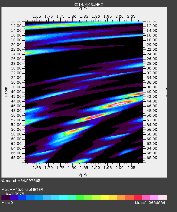
| Estimated Moho Depth: |
45.0 km |
| Estimated Crust Vp/Vs: |
2.00 |
| Assumed Crust Vp: |
6.566 km/s |
| Estimated Crust Vs: |
3.287 km/s |
| Estimated Crust Poisson's Ratio: |
0.33 |
|
| Radial Match: |
84.997665 % |
| Radial Bump: |
400 |
| Transverse Match: |
81.36097 % |
| Transverse Bump: |
400 |
| SOD ConfigId: |
3390531 |
| Insert Time: |
2019-04-12 23:45:23.799 +0000 |
| GWidth: |
2.5 |
| Max Bumps: |
400 |
| Tol: |
0.001 |
|

Signal To Noise
| Channel | StoN | STA | LTA |
| XD:MJ03: :HHZ:20140721T15:05:30.829993Z | 31.900928 | 5.302617E-6 | 1.662214E-7 |
| XD:MJ03: :HHN:20140721T15:05:30.829993Z | 7.599542 | 1.3774267E-6 | 1.8125127E-7 |
| XD:MJ03: :HHE:20140721T15:05:30.829993Z | 10.125934 | 1.196226E-6 | 1.18134885E-7 |
| Arrivals |
| Ps | 7.0 SECOND |
| PpPs | 20 SECOND |
| PsPs/PpSs | 27 SECOND |


