You are here: Home > Network List > TA - USArray Transportable Network (new EarthScope stations) Stations List
> Station K02D Willamette Meridian, OR, USA > Earthquake Result Viewer
K02D Willamette Meridian, OR, USA - Earthquake Result Viewer
| Earthquake location: |
Kuril Islands |
| Earthquake latitude/longitude: |
46.2/150.8 |
| Earthquake time(UTC): |
2013/04/19 (109) 03:05:52 GMT |
| Earthquake Depth: |
110 km |
| Earthquake Magnitude: |
7.2 MW, 7.1 MB, 7.2 MW |
| Earthquake Catalog/Contributor: |
NEIC PDE/NEIC PDE-W |
|
| Network: |
TA USArray Transportable Network (new EarthScope stations) |
| Station: |
K02D Willamette Meridian, OR, USA |
| Lat/Lon: |
42.70 N/123.67 W |
| Elevation: |
989 m |
|
| Distance: |
58.3 deg |
| Az: |
59.794 deg |
| Baz: |
305.523 deg |
| Ray Param: |
0.062631324 |
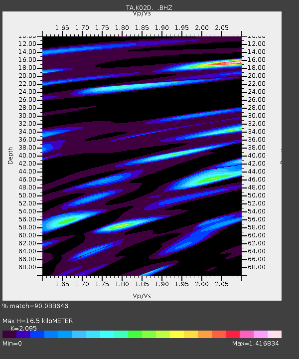
| Estimated Moho Depth: |
16.5 km |
| Estimated Crust Vp/Vs: |
2.10 |
| Assumed Crust Vp: |
6.522 km/s |
| Estimated Crust Vs: |
3.113 km/s |
| Estimated Crust Poisson's Ratio: |
0.35 |
|
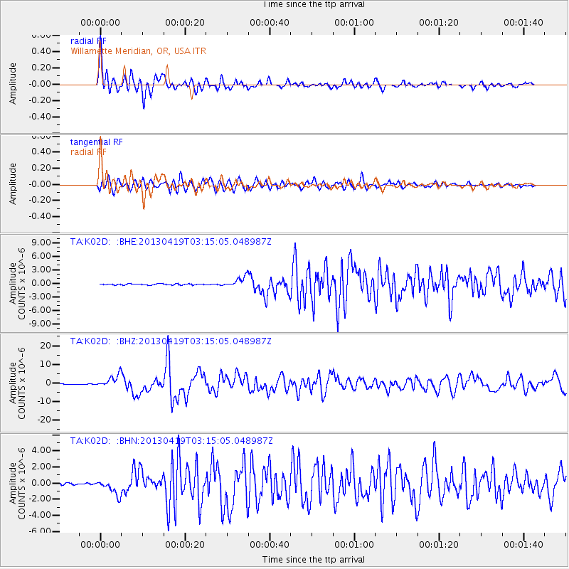
| Radial Match: |
90.088646 % |
| Radial Bump: |
400 |
| Transverse Match: |
79.98707 % |
| Transverse Bump: |
400 |
| SOD ConfigId: |
512894 |
| Insert Time: |
2013-09-13 11:41:03.478 +0000 |
| GWidth: |
2.5 |
| Max Bumps: |
400 |
| Tol: |
0.001 |
|
Signal To Noise
| Channel | StoN | STA | LTA |
| TA:K02D: :BHZ:20130419T03:15:05.048987Z | 29.639835 | 3.4354275E-6 | 1.15905756E-7 |
| TA:K02D: :BHN:20130419T03:15:05.048987Z | 9.596209 | 9.598866E-7 | 1.000277E-7 |
| TA:K02D: :BHE:20130419T03:15:05.048987Z | 9.132662 | 1.1991622E-6 | 1.3130479E-7 |
| Arrivals |
| Ps | 2.9 SECOND |
| PpPs | 7.5 SECOND |
| PsPs/PpSs | 10 SECOND |


