You are here: Home > Network List > TA - USArray Transportable Network (new EarthScope stations) Stations List
> Station K42A Prairie Point, Evansville, WI, USA > Earthquake Result Viewer
K42A Prairie Point, Evansville, WI, USA - Earthquake Result Viewer
| Earthquake location: |
Kuril Islands |
| Earthquake latitude/longitude: |
46.2/150.8 |
| Earthquake time(UTC): |
2013/04/19 (109) 03:05:52 GMT |
| Earthquake Depth: |
110 km |
| Earthquake Magnitude: |
7.2 MW, 7.1 MB, 7.2 MW |
| Earthquake Catalog/Contributor: |
NEIC PDE/NEIC PDE-W |
|
| Network: |
TA USArray Transportable Network (new EarthScope stations) |
| Station: |
K42A Prairie Point, Evansville, WI, USA |
| Lat/Lon: |
42.78 N/89.35 W |
| Elevation: |
302 m |
|
| Distance: |
76.6 deg |
| Az: |
41.03 deg |
| Baz: |
321.753 deg |
| Ray Param: |
0.050656088 |
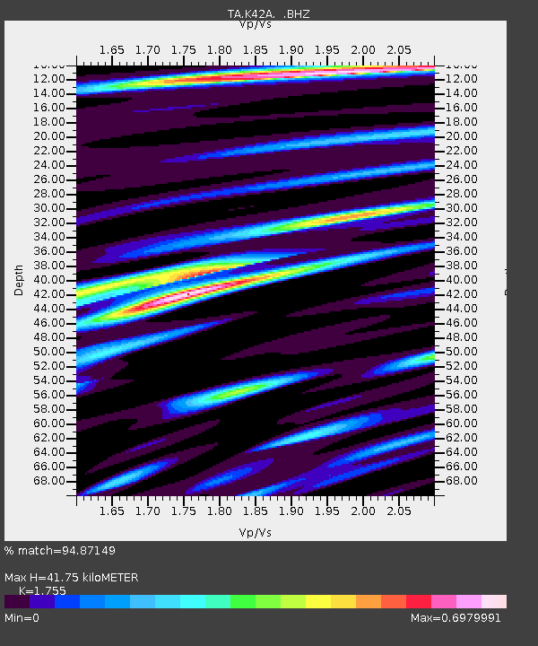
| Estimated Moho Depth: |
41.75 km |
| Estimated Crust Vp/Vs: |
1.75 |
| Assumed Crust Vp: |
6.571 km/s |
| Estimated Crust Vs: |
3.744 km/s |
| Estimated Crust Poisson's Ratio: |
0.26 |
|
| Radial Match: |
94.87149 % |
| Radial Bump: |
400 |
| Transverse Match: |
86.305435 % |
| Transverse Bump: |
400 |
| SOD ConfigId: |
512894 |
| Insert Time: |
2013-09-13 11:41:24.378 +0000 |
| GWidth: |
2.5 |
| Max Bumps: |
400 |
| Tol: |
0.001 |
|
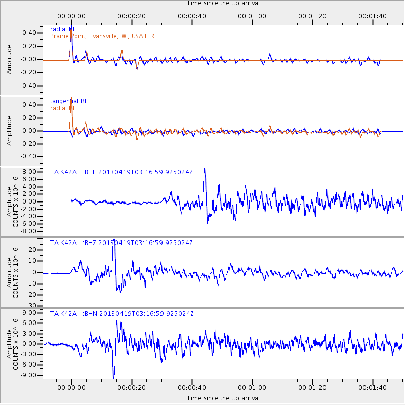
Signal To Noise
| Channel | StoN | STA | LTA |
| TA:K42A: :BHZ:20130419T03:16:59.925024Z | 18.749891 | 4.529244E-6 | 2.4156108E-7 |
| TA:K42A: :BHN:20130419T03:16:59.925024Z | 7.6005077 | 1.4032588E-6 | 1.8462698E-7 |
| TA:K42A: :BHE:20130419T03:16:59.925024Z | 3.367077 | 1.0221368E-6 | 3.0356796E-7 |
| Arrivals |
| Ps | 5.0 SECOND |
| PpPs | 17 SECOND |
| PsPs/PpSs | 22 SECOND |


