You are here: Home > Network List > TA - USArray Transportable Network (new EarthScope stations) Stations List
> Station K47A Vremontville, MI, USA > Earthquake Result Viewer
K47A Vremontville, MI, USA - Earthquake Result Viewer
| Earthquake location: |
Kuril Islands |
| Earthquake latitude/longitude: |
46.2/150.8 |
| Earthquake time(UTC): |
2013/04/19 (109) 03:05:52 GMT |
| Earthquake Depth: |
110 km |
| Earthquake Magnitude: |
7.2 MW, 7.1 MB, 7.2 MW |
| Earthquake Catalog/Contributor: |
NEIC PDE/NEIC PDE-W |
|
| Network: |
TA USArray Transportable Network (new EarthScope stations) |
| Station: |
K47A Vremontville, MI, USA |
| Lat/Lon: |
42.67 N/85.00 W |
| Elevation: |
275 m |
|
| Distance: |
78.6 deg |
| Az: |
38.48 deg |
| Baz: |
324.143 deg |
| Ray Param: |
0.049297336 |
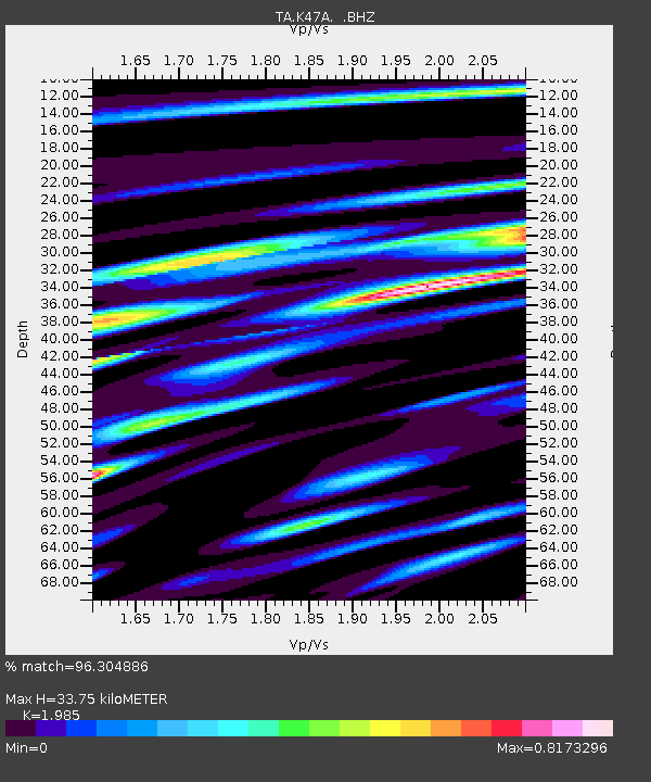
| Estimated Moho Depth: |
33.75 km |
| Estimated Crust Vp/Vs: |
1.99 |
| Assumed Crust Vp: |
6.483 km/s |
| Estimated Crust Vs: |
3.266 km/s |
| Estimated Crust Poisson's Ratio: |
0.33 |
|
| Radial Match: |
96.304886 % |
| Radial Bump: |
400 |
| Transverse Match: |
92.93637 % |
| Transverse Bump: |
400 |
| SOD ConfigId: |
512894 |
| Insert Time: |
2013-09-13 11:41:34.429 +0000 |
| GWidth: |
2.5 |
| Max Bumps: |
400 |
| Tol: |
0.001 |
|
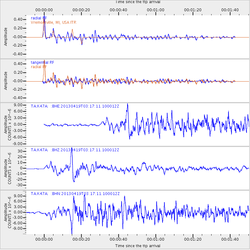
Signal To Noise
| Channel | StoN | STA | LTA |
| TA:K47A: :BHZ:20130419T03:17:11.100012Z | 28.390146 | 5.033712E-6 | 1.7730491E-7 |
| TA:K47A: :BHN:20130419T03:17:11.100012Z | 5.888655 | 1.419154E-6 | 2.40998E-7 |
| TA:K47A: :BHE:20130419T03:17:11.100012Z | 5.8360004 | 1.4178311E-6 | 2.4294567E-7 |
| Arrivals |
| Ps | 5.3 SECOND |
| PpPs | 15 SECOND |
| PsPs/PpSs | 20 SECOND |


