You are here: Home > Network List > TA - USArray Transportable Network (new EarthScope stations) Stations List
> Station KSCO Kaye Shedlock's, Cheyenne Wells, CO, USA > Earthquake Result Viewer
KSCO Kaye Shedlock's, Cheyenne Wells, CO, USA - Earthquake Result Viewer
| Earthquake location: |
Kuril Islands |
| Earthquake latitude/longitude: |
46.2/150.8 |
| Earthquake time(UTC): |
2013/04/19 (109) 03:05:52 GMT |
| Earthquake Depth: |
110 km |
| Earthquake Magnitude: |
7.2 MW, 7.1 MB, 7.2 MW |
| Earthquake Catalog/Contributor: |
NEIC PDE/NEIC PDE-W |
|
| Network: |
TA USArray Transportable Network (new EarthScope stations) |
| Station: |
KSCO Kaye Shedlock's, Cheyenne Wells, CO, USA |
| Lat/Lon: |
39.01 N/102.63 W |
| Elevation: |
1382 m |
|
| Distance: |
72.7 deg |
| Az: |
51.435 deg |
| Baz: |
315.828 deg |
| Ray Param: |
0.053198516 |
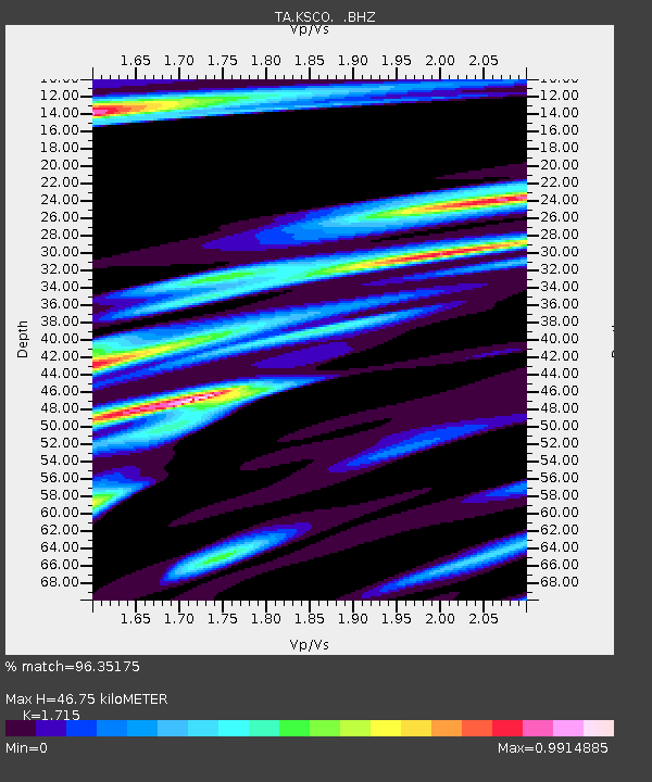
| Estimated Moho Depth: |
46.75 km |
| Estimated Crust Vp/Vs: |
1.72 |
| Assumed Crust Vp: |
6.242 km/s |
| Estimated Crust Vs: |
3.64 km/s |
| Estimated Crust Poisson's Ratio: |
0.24 |
|
| Radial Match: |
96.35175 % |
| Radial Bump: |
322 |
| Transverse Match: |
88.90039 % |
| Transverse Bump: |
400 |
| SOD ConfigId: |
512894 |
| Insert Time: |
2013-09-13 11:41:55.688 +0000 |
| GWidth: |
2.5 |
| Max Bumps: |
400 |
| Tol: |
0.001 |
|
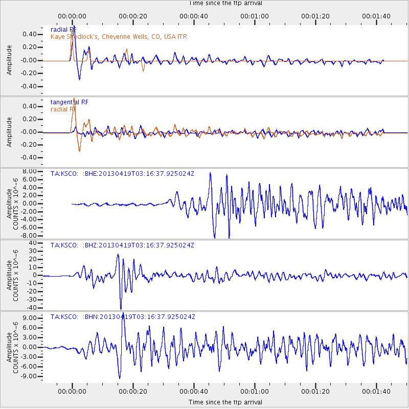
Signal To Noise
| Channel | StoN | STA | LTA |
| TA:KSCO: :BHZ:20130419T03:16:37.925024Z | 43.562946 | 4.995531E-6 | 1.14673846E-7 |
| TA:KSCO: :BHN:20130419T03:16:37.925024Z | 7.4713106 | 1.3854632E-6 | 1.8543777E-7 |
| TA:KSCO: :BHE:20130419T03:16:37.925024Z | 7.477646 | 1.2621318E-6 | 1.6878732E-7 |
| Arrivals |
| Ps | 5.5 SECOND |
| PpPs | 20 SECOND |
| PsPs/PpSs | 25 SECOND |


