You are here: Home > Network List > TA - USArray Transportable Network (new EarthScope stations) Stations List
> Station L04D Klamath Falls, OR, USA > Earthquake Result Viewer
L04D Klamath Falls, OR, USA - Earthquake Result Viewer
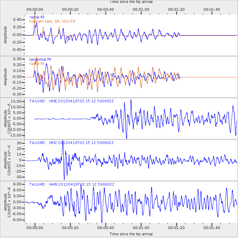
| Earthquake location: |
Kuril Islands |
| Earthquake latitude/longitude: |
46.2/150.8 |
| Earthquake time(UTC): |
2013/04/19 (109) 03:05:52 GMT |
| Earthquake Depth: |
110 km |
| Earthquake Magnitude: |
7.2 MW, 7.1 MB, 7.2 MW |
| Earthquake Catalog/Contributor: |
NEIC PDE/NEIC PDE-W |
|
| Network: |
TA USArray Transportable Network (new EarthScope stations) |
| Station: |
L04D Klamath Falls, OR, USA |
| Lat/Lon: |
42.22 N/122.30 W |
| Elevation: |
1437 m |
|
| Distance: |
59.4 deg |
| Az: |
59.555 deg |
| Baz: |
306.314 deg |
| Ray Param: |
0.06191612 |
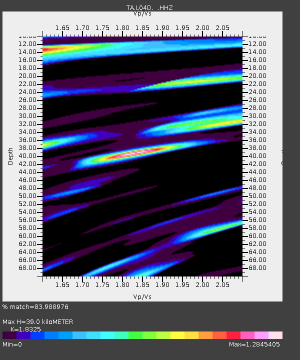
| Estimated Moho Depth: |
39.0 km |
| Estimated Crust Vp/Vs: |
1.83 |
| Assumed Crust Vp: |
6.522 km/s |
| Estimated Crust Vs: |
3.559 km/s |
| Estimated Crust Poisson's Ratio: |
0.29 |
|
| Radial Match: |
83.988976 % |
| Radial Bump: |
393 |
| Transverse Match: |
82.17609 % |
| Transverse Bump: |
351 |
| SOD ConfigId: |
512894 |
| Insert Time: |
2013-09-13 11:42:01.427 +0000 |
| GWidth: |
2.5 |
| Max Bumps: |
400 |
| Tol: |
0.001 |
|
Signal To Noise
| Channel | StoN | STA | LTA |
| TA:L04D: :HHZ:20130419T03:15:12.590002Z | 27.929605 | 4.6393297E-6 | 1.6610797E-7 |
| TA:L04D: :HHN:20130419T03:15:12.590002Z | 6.790447 | 1.0967407E-6 | 1.6151228E-7 |
| TA:L04D: :HHE:20130419T03:15:12.590002Z | 6.4217825 | 9.90124E-7 | 1.5418212E-7 |
| Arrivals |
| Ps | 5.2 SECOND |
| PpPs | 16 SECOND |
| PsPs/PpSs | 21 SECOND |


