You are here: Home > Network List > TA - USArray Transportable Network (new EarthScope stations) Stations List
> Station L53A Girard, PA, USA > Earthquake Result Viewer
L53A Girard, PA, USA - Earthquake Result Viewer
| Earthquake location: |
Kuril Islands |
| Earthquake latitude/longitude: |
46.2/150.8 |
| Earthquake time(UTC): |
2013/04/19 (109) 03:05:52 GMT |
| Earthquake Depth: |
110 km |
| Earthquake Magnitude: |
7.2 MW, 7.1 MB, 7.2 MW |
| Earthquake Catalog/Contributor: |
NEIC PDE/NEIC PDE-W |
|
| Network: |
TA USArray Transportable Network (new EarthScope stations) |
| Station: |
L53A Girard, PA, USA |
| Lat/Lon: |
41.95 N/80.26 W |
| Elevation: |
355 m |
|
| Distance: |
81.2 deg |
| Az: |
35.948 deg |
| Baz: |
326.877 deg |
| Ray Param: |
0.04753527 |
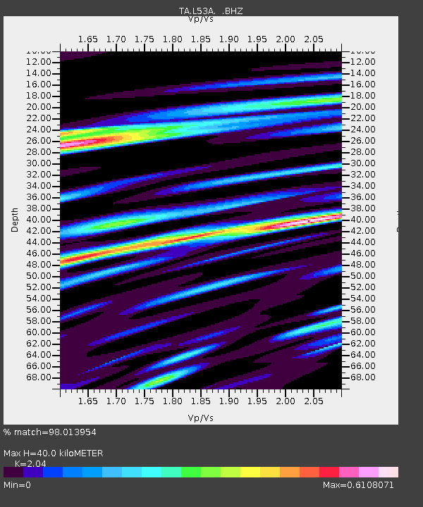
| Estimated Moho Depth: |
40.0 km |
| Estimated Crust Vp/Vs: |
2.04 |
| Assumed Crust Vp: |
6.483 km/s |
| Estimated Crust Vs: |
3.178 km/s |
| Estimated Crust Poisson's Ratio: |
0.34 |
|
| Radial Match: |
98.013954 % |
| Radial Bump: |
346 |
| Transverse Match: |
93.952576 % |
| Transverse Bump: |
400 |
| SOD ConfigId: |
512894 |
| Insert Time: |
2013-09-13 11:42:37.496 +0000 |
| GWidth: |
2.5 |
| Max Bumps: |
400 |
| Tol: |
0.001 |
|

Signal To Noise
| Channel | StoN | STA | LTA |
| TA:L53A: :BHZ:20130419T03:17:24.949011Z | 35.083084 | 6.473142E-6 | 1.8450892E-7 |
| TA:L53A: :BHN:20130419T03:17:24.949011Z | 9.652391 | 2.0470736E-6 | 2.1207943E-7 |
| TA:L53A: :BHE:20130419T03:17:24.949011Z | 6.356055 | 1.1773153E-6 | 1.8522736E-7 |
| Arrivals |
| Ps | 6.6 SECOND |
| PpPs | 18 SECOND |
| PsPs/PpSs | 25 SECOND |


