You are here: Home > Network List > YT07 - POLENET Stations List
> Station MPAT MPAT > Earthquake Result Viewer
MPAT MPAT - Earthquake Result Viewer
| Earthquake location: |
Fiji Islands Region |
| Earthquake latitude/longitude: |
-19.8/-178.4 |
| Earthquake time(UTC): |
2014/07/21 (202) 14:54:40 GMT |
| Earthquake Depth: |
616 km |
| Earthquake Magnitude: |
6.9 MWB, 6.9 MI |
| Earthquake Catalog/Contributor: |
NEIC PDE/NEIC ALERT |
|
| Network: |
YT POLENET |
| Station: |
MPAT MPAT |
| Lat/Lon: |
78.03 S/155.02 W |
| Elevation: |
540 m |
|
| Distance: |
59.4 deg |
| Az: |
174.468 deg |
| Baz: |
334.218 deg |
| Ray Param: |
0.05969953 |
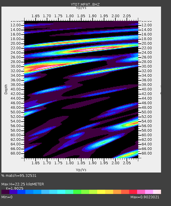
| Estimated Moho Depth: |
22.25 km |
| Estimated Crust Vp/Vs: |
1.90 |
| Assumed Crust Vp: |
6.43 km/s |
| Estimated Crust Vs: |
3.38 km/s |
| Estimated Crust Poisson's Ratio: |
0.31 |
|
| Radial Match: |
95.32531 % |
| Radial Bump: |
400 |
| Transverse Match: |
87.44774 % |
| Transverse Bump: |
400 |
| SOD ConfigId: |
3390531 |
| Insert Time: |
2019-04-12 23:46:03.672 +0000 |
| GWidth: |
2.5 |
| Max Bumps: |
400 |
| Tol: |
0.001 |
|

Signal To Noise
| Channel | StoN | STA | LTA |
| YT:MPAT: :BHZ:20140721T15:03:14.749976Z | 43.209877 | 5.747713E-6 | 1.330185E-7 |
| YT:MPAT: :BHN:20140721T15:03:14.749976Z | 32.28815 | 2.3333923E-6 | 7.226776E-8 |
| YT:MPAT: :BHE:20140721T15:03:14.749976Z | 14.083204 | 1.1738423E-6 | 8.335051E-8 |
| Arrivals |
| Ps | 3.3 SECOND |
| PpPs | 9.6 SECOND |
| PsPs/PpSs | 13 SECOND |


