You are here: Home > Network List > TA - USArray Transportable Network (new EarthScope stations) Stations List
> Station L54A Sinclairville, NY, USA > Earthquake Result Viewer
L54A Sinclairville, NY, USA - Earthquake Result Viewer
| Earthquake location: |
Kuril Islands |
| Earthquake latitude/longitude: |
46.2/150.8 |
| Earthquake time(UTC): |
2013/04/19 (109) 03:05:52 GMT |
| Earthquake Depth: |
110 km |
| Earthquake Magnitude: |
7.2 MW, 7.1 MB, 7.2 MW |
| Earthquake Catalog/Contributor: |
NEIC PDE/NEIC PDE-W |
|
| Network: |
TA USArray Transportable Network (new EarthScope stations) |
| Station: |
L54A Sinclairville, NY, USA |
| Lat/Lon: |
42.23 N/79.32 W |
| Elevation: |
432 m |
|
| Distance: |
81.3 deg |
| Az: |
35.197 deg |
| Baz: |
327.393 deg |
| Ray Param: |
0.047433577 |
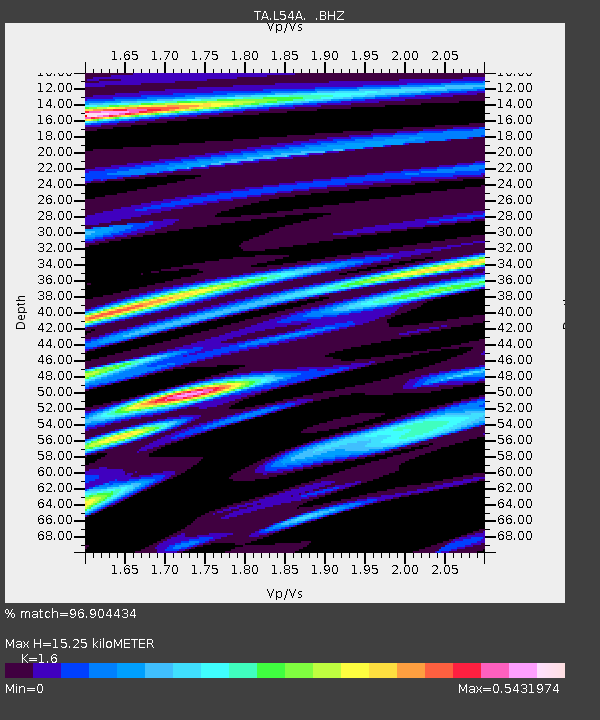
| Estimated Moho Depth: |
15.25 km |
| Estimated Crust Vp/Vs: |
1.60 |
| Assumed Crust Vp: |
6.419 km/s |
| Estimated Crust Vs: |
4.012 km/s |
| Estimated Crust Poisson's Ratio: |
0.18 |
|
| Radial Match: |
96.904434 % |
| Radial Bump: |
385 |
| Transverse Match: |
92.85866 % |
| Transverse Bump: |
400 |
| SOD ConfigId: |
512894 |
| Insert Time: |
2013-09-13 11:42:40.003 +0000 |
| GWidth: |
2.5 |
| Max Bumps: |
400 |
| Tol: |
0.001 |
|
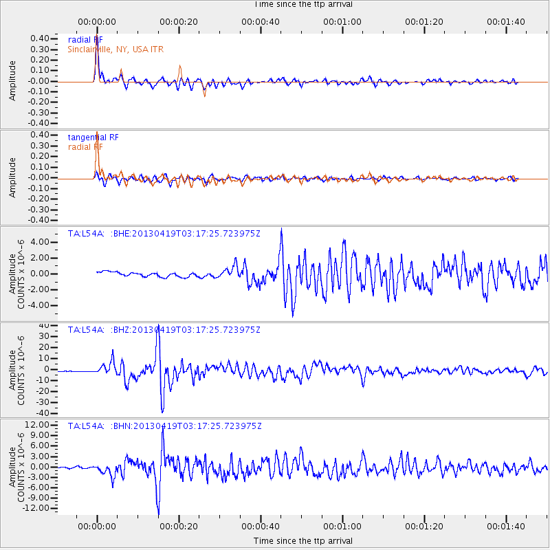
Signal To Noise
| Channel | StoN | STA | LTA |
| TA:L54A: :BHZ:20130419T03:17:25.723975Z | 27.863619 | 6.127615E-6 | 2.1991453E-7 |
| TA:L54A: :BHN:20130419T03:17:25.723975Z | 9.277318 | 1.8381768E-6 | 1.9813665E-7 |
| TA:L54A: :BHE:20130419T03:17:25.723975Z | 2.767053 | 7.814825E-7 | 2.8242414E-7 |
| Arrivals |
| Ps | 1.5 SECOND |
| PpPs | 6.0 SECOND |
| PsPs/PpSs | 7.5 SECOND |


