You are here: Home > Network List > TA - USArray Transportable Network (new EarthScope stations) Stations List
> Station M02C Callahan, CA, USA > Earthquake Result Viewer
M02C Callahan, CA, USA - Earthquake Result Viewer
| Earthquake location: |
Kuril Islands |
| Earthquake latitude/longitude: |
46.2/150.8 |
| Earthquake time(UTC): |
2013/04/19 (109) 03:05:52 GMT |
| Earthquake Depth: |
110 km |
| Earthquake Magnitude: |
7.2 MW, 7.1 MB, 7.2 MW |
| Earthquake Catalog/Contributor: |
NEIC PDE/NEIC PDE-W |
|
| Network: |
TA USArray Transportable Network (new EarthScope stations) |
| Station: |
M02C Callahan, CA, USA |
| Lat/Lon: |
41.39 N/122.85 W |
| Elevation: |
0.0 m |
|
| Distance: |
59.5 deg |
| Az: |
60.609 deg |
| Baz: |
306.486 deg |
| Ray Param: |
0.06181291 |
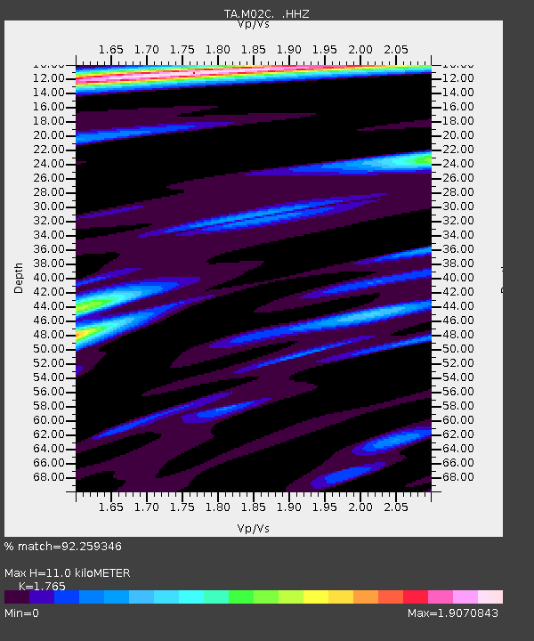
| Estimated Moho Depth: |
11.0 km |
| Estimated Crust Vp/Vs: |
1.76 |
| Assumed Crust Vp: |
6.566 km/s |
| Estimated Crust Vs: |
3.72 km/s |
| Estimated Crust Poisson's Ratio: |
0.26 |
|
| Radial Match: |
92.259346 % |
| Radial Bump: |
400 |
| Transverse Match: |
83.53395 % |
| Transverse Bump: |
400 |
| SOD ConfigId: |
512894 |
| Insert Time: |
2013-09-13 11:42:48.101 +0000 |
| GWidth: |
2.5 |
| Max Bumps: |
400 |
| Tol: |
0.001 |
|

Signal To Noise
| Channel | StoN | STA | LTA |
| TA:M02C: :HHZ:20130419T03:15:13.680029Z | 26.408571 | 2.596603E-6 | 9.832425E-8 |
| TA:M02C: :HHN:20130419T03:15:13.680029Z | 6.711758 | 6.6385127E-7 | 9.89087E-8 |
| TA:M02C: :HHE:20130419T03:15:13.680029Z | 9.093877 | 8.337334E-7 | 9.168075E-8 |
| Arrivals |
| Ps | 1.3 SECOND |
| PpPs | 4.4 SECOND |
| PsPs/PpSs | 5.8 SECOND |


