You are here: Home > Network List > TA - USArray Transportable Network (new EarthScope stations) Stations List
> Station M44A Midewin, Midewin Nat. Tallgrass Prarie, IL, USA > Earthquake Result Viewer
M44A Midewin, Midewin Nat. Tallgrass Prarie, IL, USA - Earthquake Result Viewer
| Earthquake location: |
Kuril Islands |
| Earthquake latitude/longitude: |
46.2/150.8 |
| Earthquake time(UTC): |
2013/04/19 (109) 03:05:52 GMT |
| Earthquake Depth: |
110 km |
| Earthquake Magnitude: |
7.2 MW, 7.1 MB, 7.2 MW |
| Earthquake Catalog/Contributor: |
NEIC PDE/NEIC PDE-W |
|
| Network: |
TA USArray Transportable Network (new EarthScope stations) |
| Station: |
M44A Midewin, Midewin Nat. Tallgrass Prarie, IL, USA |
| Lat/Lon: |
41.39 N/88.04 W |
| Elevation: |
207 m |
|
| Distance: |
78.3 deg |
| Az: |
41.118 deg |
| Baz: |
322.642 deg |
| Ray Param: |
0.04951509 |
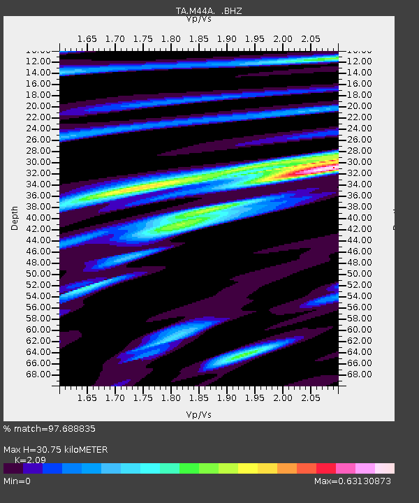
| Estimated Moho Depth: |
30.75 km |
| Estimated Crust Vp/Vs: |
2.09 |
| Assumed Crust Vp: |
6.498 km/s |
| Estimated Crust Vs: |
3.109 km/s |
| Estimated Crust Poisson's Ratio: |
0.35 |
|
| Radial Match: |
97.688835 % |
| Radial Bump: |
364 |
| Transverse Match: |
91.58985 % |
| Transverse Bump: |
400 |
| SOD ConfigId: |
512894 |
| Insert Time: |
2013-09-13 11:43:04.619 +0000 |
| GWidth: |
2.5 |
| Max Bumps: |
400 |
| Tol: |
0.001 |
|
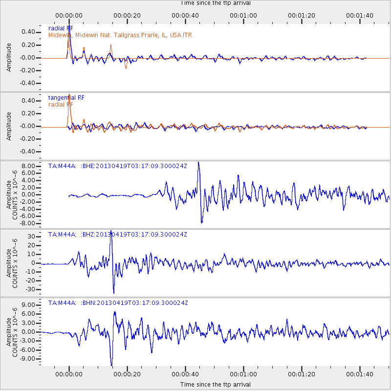
Signal To Noise
| Channel | StoN | STA | LTA |
| TA:M44A: :BHZ:20130419T03:17:09.300024Z | 26.258501 | 5.050403E-6 | 1.9233403E-7 |
| TA:M44A: :BHN:20130419T03:17:09.300024Z | 8.969263 | 1.6389333E-6 | 1.8272775E-7 |
| TA:M44A: :BHE:20130419T03:17:09.300024Z | 5.9962955 | 1.3442374E-6 | 2.2417797E-7 |
| Arrivals |
| Ps | 5.3 SECOND |
| PpPs | 14 SECOND |
| PsPs/PpSs | 20 SECOND |


