You are here: Home > Network List > TA - USArray Transportable Network (new EarthScope stations) Stations List
> Station M47A Cromwell, IN, USA > Earthquake Result Viewer
M47A Cromwell, IN, USA - Earthquake Result Viewer
| Earthquake location: |
Kuril Islands |
| Earthquake latitude/longitude: |
46.2/150.8 |
| Earthquake time(UTC): |
2013/04/19 (109) 03:05:52 GMT |
| Earthquake Depth: |
110 km |
| Earthquake Magnitude: |
7.2 MW, 7.1 MB, 7.2 MW |
| Earthquake Catalog/Contributor: |
NEIC PDE/NEIC PDE-W |
|
| Network: |
TA USArray Transportable Network (new EarthScope stations) |
| Station: |
M47A Cromwell, IN, USA |
| Lat/Lon: |
41.36 N/85.62 W |
| Elevation: |
283 m |
|
| Distance: |
79.4 deg |
| Az: |
39.646 deg |
| Baz: |
323.951 deg |
| Ray Param: |
0.048760984 |
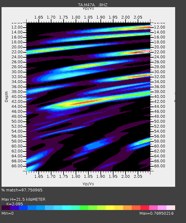
| Estimated Moho Depth: |
21.5 km |
| Estimated Crust Vp/Vs: |
2.10 |
| Assumed Crust Vp: |
6.498 km/s |
| Estimated Crust Vs: |
3.101 km/s |
| Estimated Crust Poisson's Ratio: |
0.35 |
|
| Radial Match: |
97.758965 % |
| Radial Bump: |
398 |
| Transverse Match: |
89.50647 % |
| Transverse Bump: |
400 |
| SOD ConfigId: |
512894 |
| Insert Time: |
2013-09-13 11:43:13.905 +0000 |
| GWidth: |
2.5 |
| Max Bumps: |
400 |
| Tol: |
0.001 |
|
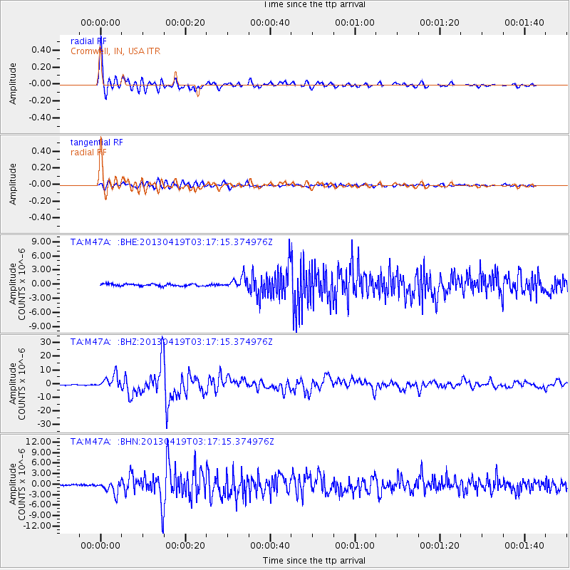
Signal To Noise
| Channel | StoN | STA | LTA |
| TA:M47A: :BHZ:20130419T03:17:15.374976Z | 26.41207 | 4.9957453E-6 | 1.891463E-7 |
| TA:M47A: :BHN:20130419T03:17:15.374976Z | 11.638136 | 1.7889862E-6 | 1.537176E-7 |
| TA:M47A: :BHE:20130419T03:17:15.374976Z | 5.708072 | 1.2549647E-6 | 2.1985788E-7 |
| Arrivals |
| Ps | 3.7 SECOND |
| PpPs | 10.0 SECOND |
| PsPs/PpSs | 14 SECOND |


