You are here: Home > Network List > YT07 - POLENET Stations List
> Station WAWA WAWA > Earthquake Result Viewer
WAWA WAWA - Earthquake Result Viewer
| Earthquake location: |
Fiji Islands Region |
| Earthquake latitude/longitude: |
-19.8/-178.4 |
| Earthquake time(UTC): |
2014/07/21 (202) 14:54:40 GMT |
| Earthquake Depth: |
616 km |
| Earthquake Magnitude: |
6.9 MWB, 6.9 MI |
| Earthquake Catalog/Contributor: |
NEIC PDE/NEIC ALERT |
|
| Network: |
YT POLENET |
| Station: |
WAWA WAWA |
| Lat/Lon: |
81.58 S/28.42 W |
| Elevation: |
1202 m |
|
| Distance: |
77.7 deg |
| Az: |
175.677 deg |
| Baz: |
208.788 deg |
| Ray Param: |
0.048154503 |
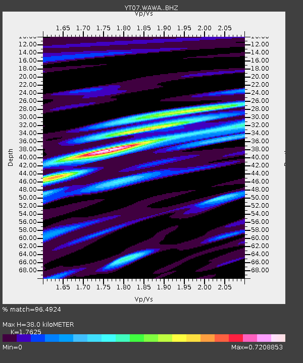
| Estimated Moho Depth: |
38.0 km |
| Estimated Crust Vp/Vs: |
1.76 |
| Assumed Crust Vp: |
6.424 km/s |
| Estimated Crust Vs: |
3.645 km/s |
| Estimated Crust Poisson's Ratio: |
0.26 |
|
| Radial Match: |
96.4924 % |
| Radial Bump: |
400 |
| Transverse Match: |
89.46344 % |
| Transverse Bump: |
400 |
| SOD ConfigId: |
3390531 |
| Insert Time: |
2019-04-12 23:46:11.748 +0000 |
| GWidth: |
2.5 |
| Max Bumps: |
400 |
| Tol: |
0.001 |
|

Signal To Noise
| Channel | StoN | STA | LTA |
| YT:WAWA: :BHZ:20140721T15:05:04.623999Z | 65.80438 | 7.420372E-6 | 1.12764106E-7 |
| YT:WAWA: :BHN:20140721T15:05:04.623999Z | 24.413216 | 1.8303509E-6 | 7.497377E-8 |
| YT:WAWA: :BHE:20140721T15:05:04.623999Z | 17.646954 | 1.9073773E-6 | 1.08085366E-7 |
| Arrivals |
| Ps | 4.6 SECOND |
| PpPs | 16 SECOND |
| PsPs/PpSs | 21 SECOND |


