You are here: Home > Network List > TA - USArray Transportable Network (new EarthScope stations) Stations List
> Station M54A Oil Creek State Park, Oil City, PA, USA > Earthquake Result Viewer
M54A Oil Creek State Park, Oil City, PA, USA - Earthquake Result Viewer
| Earthquake location: |
Kuril Islands |
| Earthquake latitude/longitude: |
46.2/150.8 |
| Earthquake time(UTC): |
2013/04/19 (109) 03:05:52 GMT |
| Earthquake Depth: |
110 km |
| Earthquake Magnitude: |
7.2 MW, 7.1 MB, 7.2 MW |
| Earthquake Catalog/Contributor: |
NEIC PDE/NEIC PDE-W |
|
| Network: |
TA USArray Transportable Network (new EarthScope stations) |
| Station: |
M54A Oil Creek State Park, Oil City, PA, USA |
| Lat/Lon: |
41.51 N/79.66 W |
| Elevation: |
488 m |
|
| Distance: |
81.8 deg |
| Az: |
35.815 deg |
| Baz: |
327.252 deg |
| Ray Param: |
0.04710523 |
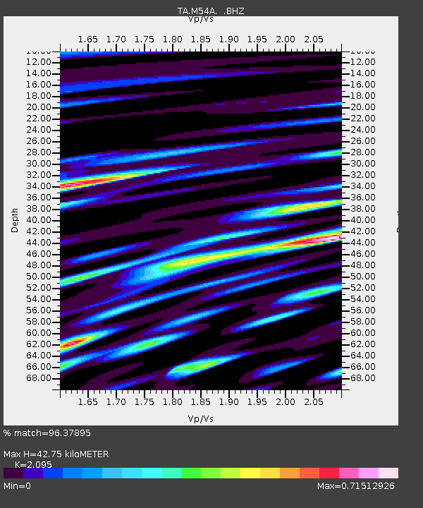
| Estimated Moho Depth: |
42.75 km |
| Estimated Crust Vp/Vs: |
2.10 |
| Assumed Crust Vp: |
6.121 km/s |
| Estimated Crust Vs: |
2.921 km/s |
| Estimated Crust Poisson's Ratio: |
0.35 |
|
| Radial Match: |
96.37895 % |
| Radial Bump: |
400 |
| Transverse Match: |
92.750885 % |
| Transverse Bump: |
400 |
| SOD ConfigId: |
512894 |
| Insert Time: |
2013-09-13 11:43:35.260 +0000 |
| GWidth: |
2.5 |
| Max Bumps: |
400 |
| Tol: |
0.001 |
|

Signal To Noise
| Channel | StoN | STA | LTA |
| TA:M54A: :BHZ:20130419T03:17:28.175024Z | 26.23833 | 5.9282092E-6 | 2.2593697E-7 |
| TA:M54A: :BHN:20130419T03:17:28.175024Z | 8.113299 | 1.8925441E-6 | 2.3326442E-7 |
| TA:M54A: :BHE:20130419T03:17:28.175024Z | 7.4599266 | 1.3444223E-6 | 1.8021925E-7 |
| Arrivals |
| Ps | 7.8 SECOND |
| PpPs | 21 SECOND |
| PsPs/PpSs | 29 SECOND |


