You are here: Home > Network List > TA - USArray Transportable Network (new EarthScope stations) Stations List
> Station N02D Trinity Center, CA, USA > Earthquake Result Viewer
N02D Trinity Center, CA, USA - Earthquake Result Viewer
| Earthquake location: |
Kuril Islands |
| Earthquake latitude/longitude: |
46.2/150.8 |
| Earthquake time(UTC): |
2013/04/19 (109) 03:05:52 GMT |
| Earthquake Depth: |
110 km |
| Earthquake Magnitude: |
7.2 MW, 7.1 MB, 7.2 MW |
| Earthquake Catalog/Contributor: |
NEIC PDE/NEIC PDE-W |
|
| Network: |
TA USArray Transportable Network (new EarthScope stations) |
| Station: |
N02D Trinity Center, CA, USA |
| Lat/Lon: |
40.97 N/122.71 W |
| Elevation: |
937 m |
|
| Distance: |
59.9 deg |
| Az: |
60.92 deg |
| Baz: |
306.74 deg |
| Ray Param: |
0.06159194 |
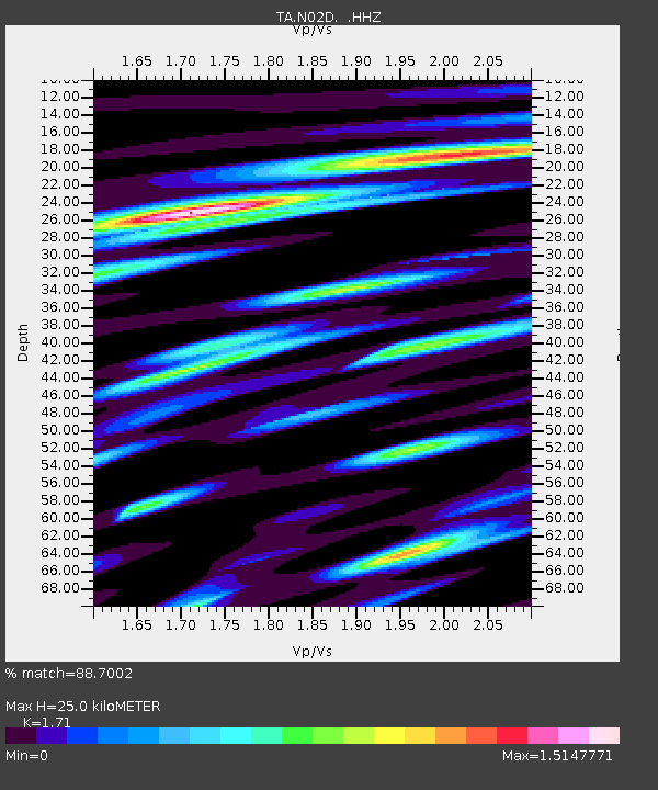
| Estimated Moho Depth: |
25.0 km |
| Estimated Crust Vp/Vs: |
1.71 |
| Assumed Crust Vp: |
6.566 km/s |
| Estimated Crust Vs: |
3.84 km/s |
| Estimated Crust Poisson's Ratio: |
0.24 |
|
| Radial Match: |
88.7002 % |
| Radial Bump: |
400 |
| Transverse Match: |
80.231125 % |
| Transverse Bump: |
400 |
| SOD ConfigId: |
512894 |
| Insert Time: |
2013-09-13 11:43:51.200 +0000 |
| GWidth: |
2.5 |
| Max Bumps: |
400 |
| Tol: |
0.001 |
|

Signal To Noise
| Channel | StoN | STA | LTA |
| TA:N02D: :HHZ:20130419T03:15:16.009985Z | 27.326334 | 2.8735742E-6 | 1.0515769E-7 |
| TA:N02D: :HHN:20130419T03:15:16.009985Z | 8.041219 | 6.6802227E-7 | 8.307475E-8 |
| TA:N02D: :HHE:20130419T03:15:16.009985Z | 10.171698 | 9.94949E-7 | 9.781543E-8 |
| Arrivals |
| Ps | 2.8 SECOND |
| PpPs | 9.8 SECOND |
| PsPs/PpSs | 13 SECOND |


