You are here: Home > Network List > TA - USArray Transportable Network (new EarthScope stations) Stations List
> Station N44A Piper City, IL, USA > Earthquake Result Viewer
N44A Piper City, IL, USA - Earthquake Result Viewer
| Earthquake location: |
Kuril Islands |
| Earthquake latitude/longitude: |
46.2/150.8 |
| Earthquake time(UTC): |
2013/04/19 (109) 03:05:52 GMT |
| Earthquake Depth: |
110 km |
| Earthquake Magnitude: |
7.2 MW, 7.1 MB, 7.2 MW |
| Earthquake Catalog/Contributor: |
NEIC PDE/NEIC PDE-W |
|
| Network: |
TA USArray Transportable Network (new EarthScope stations) |
| Station: |
N44A Piper City, IL, USA |
| Lat/Lon: |
40.80 N/88.13 W |
| Elevation: |
202 m |
|
| Distance: |
78.7 deg |
| Az: |
41.54 deg |
| Baz: |
322.668 deg |
| Ray Param: |
0.04922625 |
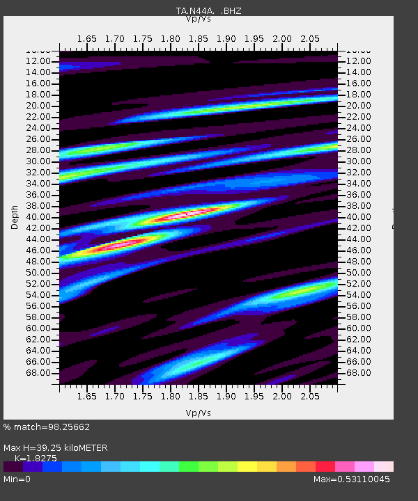
| Estimated Moho Depth: |
39.25 km |
| Estimated Crust Vp/Vs: |
1.83 |
| Assumed Crust Vp: |
6.498 km/s |
| Estimated Crust Vs: |
3.555 km/s |
| Estimated Crust Poisson's Ratio: |
0.29 |
|
| Radial Match: |
98.25662 % |
| Radial Bump: |
289 |
| Transverse Match: |
89.34665 % |
| Transverse Bump: |
400 |
| SOD ConfigId: |
512894 |
| Insert Time: |
2013-09-13 11:44:04.463 +0000 |
| GWidth: |
2.5 |
| Max Bumps: |
400 |
| Tol: |
0.001 |
|

Signal To Noise
| Channel | StoN | STA | LTA |
| TA:N44A: :BHZ:20130419T03:17:11.675024Z | 25.407286 | 5.2153027E-6 | 2.05268E-7 |
| TA:N44A: :BHN:20130419T03:17:11.675024Z | 9.311402 | 1.8291068E-6 | 1.9643731E-7 |
| TA:N44A: :BHE:20130419T03:17:11.675024Z | 6.022167 | 1.3824579E-6 | 2.2956154E-7 |
| Arrivals |
| Ps | 5.1 SECOND |
| PpPs | 17 SECOND |
| PsPs/PpSs | 22 SECOND |


