You are here: Home > Network List > TA - USArray Transportable Network (new EarthScope stations) Stations List
> Station N48A Decatur, IN, USA > Earthquake Result Viewer
N48A Decatur, IN, USA - Earthquake Result Viewer

| Earthquake location: |
Kuril Islands |
| Earthquake latitude/longitude: |
46.2/150.8 |
| Earthquake time(UTC): |
2013/04/19 (109) 03:05:52 GMT |
| Earthquake Depth: |
110 km |
| Earthquake Magnitude: |
7.2 MW, 7.1 MB, 7.2 MW |
| Earthquake Catalog/Contributor: |
NEIC PDE/NEIC PDE-W |
|
| Network: |
TA USArray Transportable Network (new EarthScope stations) |
| Station: |
N48A Decatur, IN, USA |
| Lat/Lon: |
40.86 N/85.03 W |
| Elevation: |
250 m |
|
| Distance: |
80.0 deg |
| Az: |
39.573 deg |
| Baz: |
324.328 deg |
| Ray Param: |
0.04830668 |
| Estimated Moho Depth: |
28.25 km |
| Estimated Crust Vp/Vs: |
2.10 |
| Assumed Crust Vp: |
6.498 km/s |
| Estimated Crust Vs: |
3.098 km/s |
| Estimated Crust Poisson's Ratio: |
0.35 |
|
| Radial Match: |
98.4373 % |
| Radial Bump: |
260 |
| Transverse Match: |
93.99922 % |
| Transverse Bump: |
400 |
| SOD ConfigId: |
512894 |
| Insert Time: |
2013-09-13 11:44:15.242 +0000 |
| GWidth: |
2.5 |
| Max Bumps: |
400 |
| Tol: |
0.001 |
|
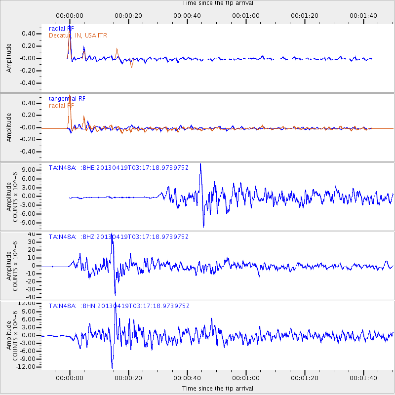
Signal To Noise
| Channel | StoN | STA | LTA |
| TA:N48A: :BHZ:20130419T03:17:18.973975Z | 46.325993 | 5.4702086E-6 | 1.1808076E-7 |
| TA:N48A: :BHN:20130419T03:17:18.973975Z | 16.282627 | 1.7047232E-6 | 1.0469583E-7 |
| TA:N48A: :BHE:20130419T03:17:18.973975Z | 12.103677 | 1.4070127E-6 | 1.16246724E-7 |
| Arrivals |
| Ps | 4.9 SECOND |
| PpPs | 13 SECOND |
| PsPs/PpSs | 18 SECOND |


