You are here: Home > Network List > TA - USArray Transportable Network (new EarthScope stations) Stations List
> Station O51A Pataskala, OH, USA > Earthquake Result Viewer
O51A Pataskala, OH, USA - Earthquake Result Viewer

| Earthquake location: |
Kuril Islands |
| Earthquake latitude/longitude: |
46.2/150.8 |
| Earthquake time(UTC): |
2013/04/19 (109) 03:05:52 GMT |
| Earthquake Depth: |
110 km |
| Earthquake Magnitude: |
7.2 MW, 7.1 MB, 7.2 MW |
| Earthquake Catalog/Contributor: |
NEIC PDE/NEIC PDE-W |
|
| Network: |
TA USArray Transportable Network (new EarthScope stations) |
| Station: |
O51A Pataskala, OH, USA |
| Lat/Lon: |
40.15 N/82.61 W |
| Elevation: |
380 m |
|
| Distance: |
81.7 deg |
| Az: |
38.454 deg |
| Baz: |
325.717 deg |
| Ray Param: |
0.047174055 |
| Estimated Moho Depth: |
44.5 km |
| Estimated Crust Vp/Vs: |
1.74 |
| Assumed Crust Vp: |
6.498 km/s |
| Estimated Crust Vs: |
3.745 km/s |
| Estimated Crust Poisson's Ratio: |
0.25 |
|
| Radial Match: |
97.827286 % |
| Radial Bump: |
400 |
| Transverse Match: |
94.04628 % |
| Transverse Bump: |
400 |
| SOD ConfigId: |
512894 |
| Insert Time: |
2013-09-13 11:45:15.869 +0000 |
| GWidth: |
2.5 |
| Max Bumps: |
400 |
| Tol: |
0.001 |
|
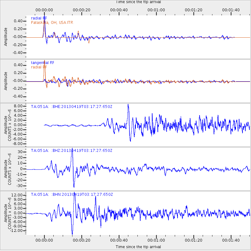
Signal To Noise
| Channel | StoN | STA | LTA |
| TA:O51A: :BHZ:20130419T03:17:27.650Z | 35.14239 | 5.305104E-6 | 1.5096025E-7 |
| TA:O51A: :BHN:20130419T03:17:27.650Z | 11.31108 | 1.8176328E-6 | 1.606949E-7 |
| TA:O51A: :BHE:20130419T03:17:27.650Z | 5.6203294 | 1.0357539E-6 | 1.8428705E-7 |
| Arrivals |
| Ps | 5.2 SECOND |
| PpPs | 18 SECOND |
| PsPs/PpSs | 23 SECOND |


