You are here: Home > Network List > TA - USArray Transportable Network (new EarthScope stations) Stations List
> Station O56A Blue Knob State Park, Imler, PA, USA > Earthquake Result Viewer
O56A Blue Knob State Park, Imler, PA, USA - Earthquake Result Viewer
| Earthquake location: |
Kuril Islands |
| Earthquake latitude/longitude: |
46.2/150.8 |
| Earthquake time(UTC): |
2013/04/19 (109) 03:05:52 GMT |
| Earthquake Depth: |
110 km |
| Earthquake Magnitude: |
7.2 MW, 7.1 MB, 7.2 MW |
| Earthquake Catalog/Contributor: |
NEIC PDE/NEIC PDE-W |
|
| Network: |
TA USArray Transportable Network (new EarthScope stations) |
| Station: |
O56A Blue Knob State Park, Imler, PA, USA |
| Lat/Lon: |
40.27 N/78.57 W |
| Elevation: |
684 m |
|
| Distance: |
83.3 deg |
| Az: |
35.775 deg |
| Baz: |
327.963 deg |
| Ray Param: |
0.04606835 |
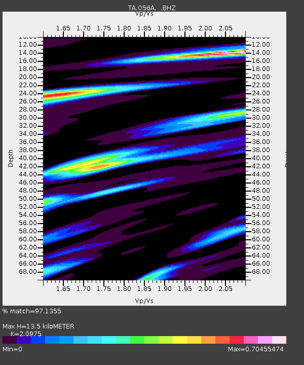
| Estimated Moho Depth: |
13.5 km |
| Estimated Crust Vp/Vs: |
2.10 |
| Assumed Crust Vp: |
6.121 km/s |
| Estimated Crust Vs: |
2.918 km/s |
| Estimated Crust Poisson's Ratio: |
0.35 |
|
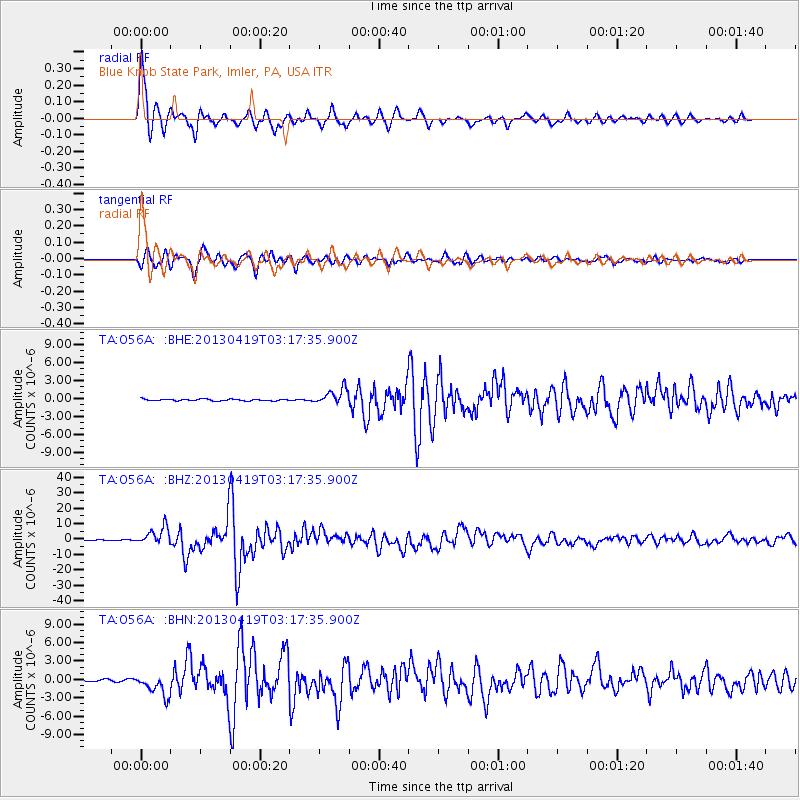
| Radial Match: |
97.1355 % |
| Radial Bump: |
400 |
| Transverse Match: |
94.92779 % |
| Transverse Bump: |
400 |
| SOD ConfigId: |
512894 |
| Insert Time: |
2013-09-13 11:45:33.055 +0000 |
| GWidth: |
2.5 |
| Max Bumps: |
400 |
| Tol: |
0.001 |
|
Signal To Noise
| Channel | StoN | STA | LTA |
| TA:O56A: :BHZ:20130419T03:17:35.900Z | 26.200836 | 5.74218E-6 | 2.1916017E-7 |
| TA:O56A: :BHN:20130419T03:17:35.900Z | 10.439425 | 1.7979181E-6 | 1.7222386E-7 |
| TA:O56A: :BHE:20130419T03:17:35.900Z | 9.311117 | 1.3150933E-6 | 1.4123904E-7 |
| Arrivals |
| Ps | 2.5 SECOND |
| PpPs | 6.7 SECOND |
| PsPs/PpSs | 9.2 SECOND |


