You are here: Home > Network List > TA - USArray Transportable Network (new EarthScope stations) Stations List
> Station P45A Graceland, Paris, IL, USA > Earthquake Result Viewer
P45A Graceland, Paris, IL, USA - Earthquake Result Viewer

| Earthquake location: |
Kuril Islands |
| Earthquake latitude/longitude: |
46.2/150.8 |
| Earthquake time(UTC): |
2013/04/19 (109) 03:05:52 GMT |
| Earthquake Depth: |
110 km |
| Earthquake Magnitude: |
7.2 MW, 7.1 MB, 7.2 MW |
| Earthquake Catalog/Contributor: |
NEIC PDE/NEIC PDE-W |
|
| Network: |
TA USArray Transportable Network (new EarthScope stations) |
| Station: |
P45A Graceland, Paris, IL, USA |
| Lat/Lon: |
39.53 N/87.74 W |
| Elevation: |
193 m |
|
| Distance: |
79.9 deg |
| Az: |
42.076 deg |
| Baz: |
323.018 deg |
| Ray Param: |
0.04841657 |
| Estimated Moho Depth: |
22.25 km |
| Estimated Crust Vp/Vs: |
2.09 |
| Assumed Crust Vp: |
6.444 km/s |
| Estimated Crust Vs: |
3.087 km/s |
| Estimated Crust Poisson's Ratio: |
0.35 |
|
| Radial Match: |
95.58256 % |
| Radial Bump: |
400 |
| Transverse Match: |
90.165825 % |
| Transverse Bump: |
400 |
| SOD ConfigId: |
512894 |
| Insert Time: |
2013-09-13 11:45:41.512 +0000 |
| GWidth: |
2.5 |
| Max Bumps: |
400 |
| Tol: |
0.001 |
|
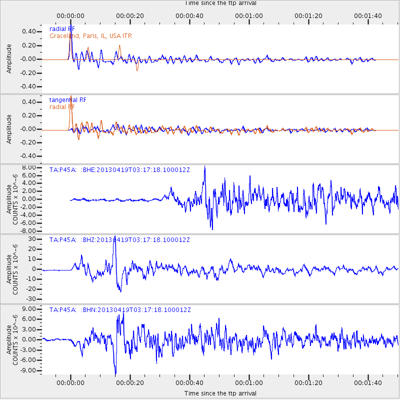
Signal To Noise
| Channel | StoN | STA | LTA |
| TA:P45A: :BHZ:20130419T03:17:18.100012Z | 23.762129 | 5.0852777E-6 | 2.1400767E-7 |
| TA:P45A: :BHN:20130419T03:17:18.100012Z | 8.53918 | 1.6811341E-6 | 1.9687302E-7 |
| TA:P45A: :BHE:20130419T03:17:18.100012Z | 7.878342 | 1.1814137E-6 | 1.4995715E-7 |
| Arrivals |
| Ps | 3.8 SECOND |
| PpPs | 10 SECOND |
| PsPs/PpSs | 14 SECOND |


