You are here: Home > Network List > TA - USArray Transportable Network (new EarthScope stations) Stations List
> Station R47A Wooly Knot Farm, English, IN, USA > Earthquake Result Viewer
R47A Wooly Knot Farm, English, IN, USA - Earthquake Result Viewer

| Earthquake location: |
Kuril Islands |
| Earthquake latitude/longitude: |
46.2/150.8 |
| Earthquake time(UTC): |
2013/04/19 (109) 03:05:52 GMT |
| Earthquake Depth: |
110 km |
| Earthquake Magnitude: |
7.2 MW, 7.1 MB, 7.2 MW |
| Earthquake Catalog/Contributor: |
NEIC PDE/NEIC PDE-W |
|
| Network: |
TA USArray Transportable Network (new EarthScope stations) |
| Station: |
R47A Wooly Knot Farm, English, IN, USA |
| Lat/Lon: |
38.30 N/86.53 W |
| Elevation: |
181 m |
|
| Distance: |
81.4 deg |
| Az: |
42.047 deg |
| Baz: |
323.774 deg |
| Ray Param: |
0.047348157 |
| Estimated Moho Depth: |
50.0 km |
| Estimated Crust Vp/Vs: |
1.63 |
| Assumed Crust Vp: |
6.444 km/s |
| Estimated Crust Vs: |
3.953 km/s |
| Estimated Crust Poisson's Ratio: |
0.20 |
|
| Radial Match: |
98.49216 % |
| Radial Bump: |
263 |
| Transverse Match: |
93.45131 % |
| Transverse Bump: |
400 |
| SOD ConfigId: |
512894 |
| Insert Time: |
2013-09-13 11:47:10.833 +0000 |
| GWidth: |
2.5 |
| Max Bumps: |
400 |
| Tol: |
0.001 |
|
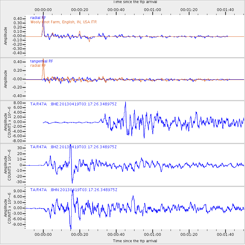
Signal To Noise
| Channel | StoN | STA | LTA |
| TA:R47A: :BHZ:20130419T03:17:26.348975Z | 33.782524 | 5.645981E-6 | 1.6712727E-7 |
| TA:R47A: :BHN:20130419T03:17:26.348975Z | 11.5015745 | 1.7387846E-6 | 1.5117796E-7 |
| TA:R47A: :BHE:20130419T03:17:26.348975Z | 8.220166 | 1.1844842E-6 | 1.4409491E-7 |
| Arrivals |
| Ps | 5.0 SECOND |
| PpPs | 20 SECOND |
| PsPs/PpSs | 25 SECOND |


