You are here: Home > Network List > TA - USArray Transportable Network (new EarthScope stations) Stations List
> Station S45A Carrier Mills, IL, USA > Earthquake Result Viewer
S45A Carrier Mills, IL, USA - Earthquake Result Viewer
| Earthquake location: |
Kuril Islands |
| Earthquake latitude/longitude: |
46.2/150.8 |
| Earthquake time(UTC): |
2013/04/19 (109) 03:05:52 GMT |
| Earthquake Depth: |
110 km |
| Earthquake Magnitude: |
7.2 MW, 7.1 MB, 7.2 MW |
| Earthquake Catalog/Contributor: |
NEIC PDE/NEIC PDE-W |
|
| Network: |
TA USArray Transportable Network (new EarthScope stations) |
| Station: |
S45A Carrier Mills, IL, USA |
| Lat/Lon: |
37.68 N/88.58 W |
| Elevation: |
122 m |
|
| Distance: |
80.9 deg |
| Az: |
43.736 deg |
| Baz: |
322.775 deg |
| Ray Param: |
0.04768032 |
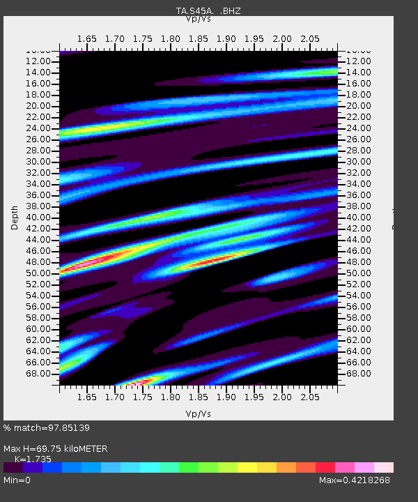
| Estimated Moho Depth: |
69.75 km |
| Estimated Crust Vp/Vs: |
1.74 |
| Assumed Crust Vp: |
6.444 km/s |
| Estimated Crust Vs: |
3.714 km/s |
| Estimated Crust Poisson's Ratio: |
0.25 |
|
| Radial Match: |
97.85139 % |
| Radial Bump: |
308 |
| Transverse Match: |
94.69915 % |
| Transverse Bump: |
400 |
| SOD ConfigId: |
512894 |
| Insert Time: |
2013-09-13 11:47:59.048 +0000 |
| GWidth: |
2.5 |
| Max Bumps: |
400 |
| Tol: |
0.001 |
|

Signal To Noise
| Channel | StoN | STA | LTA |
| TA:S45A: :BHZ:20130419T03:17:23.850012Z | 31.436316 | 5.7094203E-6 | 1.8161862E-7 |
| TA:S45A: :BHN:20130419T03:17:23.850012Z | 12.390958 | 2.0140208E-6 | 1.6253956E-7 |
| TA:S45A: :BHE:20130419T03:17:23.850012Z | 11.364414 | 1.3814266E-6 | 1.2155722E-7 |
| Arrivals |
| Ps | 8.2 SECOND |
| PpPs | 29 SECOND |
| PsPs/PpSs | 37 SECOND |


