You are here: Home > Network List > TA - USArray Transportable Network (new EarthScope stations) Stations List
> Station S46A Don Dixon Farm, Corydon, KY, USA > Earthquake Result Viewer
S46A Don Dixon Farm, Corydon, KY, USA - Earthquake Result Viewer
| Earthquake location: |
Kuril Islands |
| Earthquake latitude/longitude: |
46.2/150.8 |
| Earthquake time(UTC): |
2013/04/19 (109) 03:05:52 GMT |
| Earthquake Depth: |
110 km |
| Earthquake Magnitude: |
7.2 MW, 7.1 MB, 7.2 MW |
| Earthquake Catalog/Contributor: |
NEIC PDE/NEIC PDE-W |
|
| Network: |
TA USArray Transportable Network (new EarthScope stations) |
| Station: |
S46A Don Dixon Farm, Corydon, KY, USA |
| Lat/Lon: |
37.68 N/87.72 W |
| Elevation: |
125 m |
|
| Distance: |
81.4 deg |
| Az: |
43.177 deg |
| Baz: |
323.215 deg |
| Ray Param: |
0.04739594 |
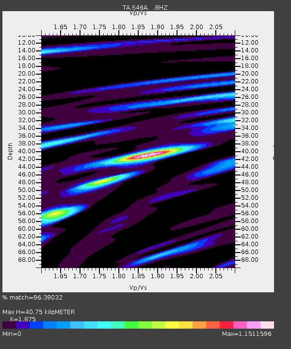
| Estimated Moho Depth: |
40.75 km |
| Estimated Crust Vp/Vs: |
1.88 |
| Assumed Crust Vp: |
6.444 km/s |
| Estimated Crust Vs: |
3.437 km/s |
| Estimated Crust Poisson's Ratio: |
0.30 |
|
| Radial Match: |
96.39032 % |
| Radial Bump: |
400 |
| Transverse Match: |
85.63172 % |
| Transverse Bump: |
400 |
| SOD ConfigId: |
512894 |
| Insert Time: |
2013-09-13 11:48:00.643 +0000 |
| GWidth: |
2.5 |
| Max Bumps: |
400 |
| Tol: |
0.001 |
|

Signal To Noise
| Channel | StoN | STA | LTA |
| TA:S46A: :BHZ:20130419T03:17:25.999976Z | 28.879944 | 5.4067073E-6 | 1.8721323E-7 |
| TA:S46A: :BHN:20130419T03:17:25.999976Z | 8.066242 | 1.6226884E-6 | 2.0117031E-7 |
| TA:S46A: :BHE:20130419T03:17:25.999976Z | 2.8157864 | 1.7514353E-6 | 6.220057E-7 |
| Arrivals |
| Ps | 5.7 SECOND |
| PpPs | 18 SECOND |
| PsPs/PpSs | 23 SECOND |


