You are here: Home > Network List > TA - USArray Transportable Network (new EarthScope stations) Stations List
> Station S49A Springfield, KY, USA > Earthquake Result Viewer
S49A Springfield, KY, USA - Earthquake Result Viewer
| Earthquake location: |
Kuril Islands |
| Earthquake latitude/longitude: |
46.2/150.8 |
| Earthquake time(UTC): |
2013/04/19 (109) 03:05:52 GMT |
| Earthquake Depth: |
110 km |
| Earthquake Magnitude: |
7.2 MW, 7.1 MB, 7.2 MW |
| Earthquake Catalog/Contributor: |
NEIC PDE/NEIC PDE-W |
|
| Network: |
TA USArray Transportable Network (new EarthScope stations) |
| Station: |
S49A Springfield, KY, USA |
| Lat/Lon: |
37.78 N/85.29 W |
| Elevation: |
230 m |
|
| Distance: |
82.4 deg |
| Az: |
41.548 deg |
| Baz: |
324.465 deg |
| Ray Param: |
0.046664868 |
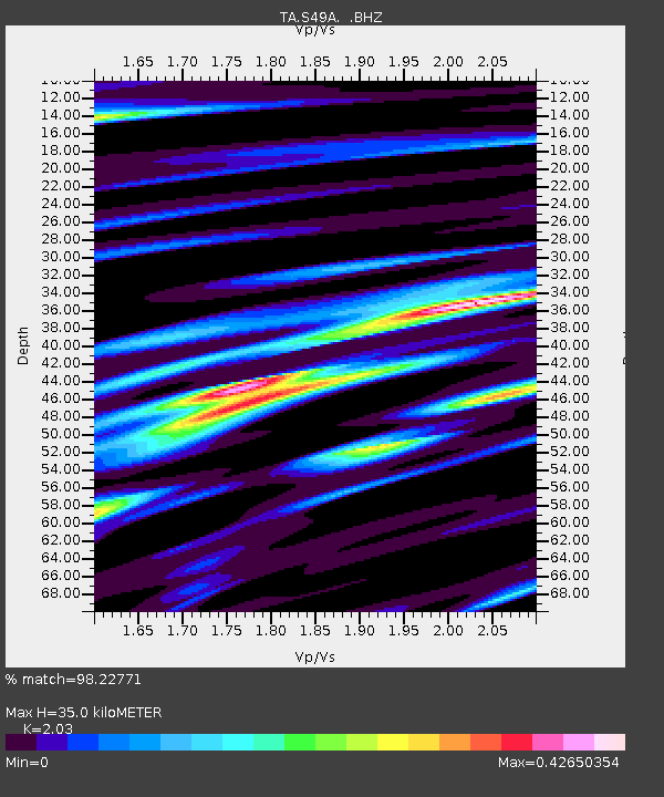
| Estimated Moho Depth: |
35.0 km |
| Estimated Crust Vp/Vs: |
2.03 |
| Assumed Crust Vp: |
6.476 km/s |
| Estimated Crust Vs: |
3.19 km/s |
| Estimated Crust Poisson's Ratio: |
0.34 |
|
| Radial Match: |
98.22771 % |
| Radial Bump: |
272 |
| Transverse Match: |
96.664 % |
| Transverse Bump: |
322 |
| SOD ConfigId: |
512894 |
| Insert Time: |
2013-09-13 11:48:09.575 +0000 |
| GWidth: |
2.5 |
| Max Bumps: |
400 |
| Tol: |
0.001 |
|

Signal To Noise
| Channel | StoN | STA | LTA |
| TA:S49A: :BHZ:20130419T03:17:31.499976Z | 31.700897 | 5.8993546E-6 | 1.8609424E-7 |
| TA:S49A: :BHN:20130419T03:17:31.499976Z | 7.590304 | 1.3110987E-6 | 1.7273337E-7 |
| TA:S49A: :BHE:20130419T03:17:31.499976Z | 15.210391 | 1.2559375E-6 | 8.257102E-8 |
| Arrivals |
| Ps | 5.7 SECOND |
| PpPs | 16 SECOND |
| PsPs/PpSs | 22 SECOND |


