You are here: Home > Network List > TA - USArray Transportable Network (new EarthScope stations) Stations List
> Station S58A Poland Farm, Powhatan, VA, USA > Earthquake Result Viewer
S58A Poland Farm, Powhatan, VA, USA - Earthquake Result Viewer
| Earthquake location: |
Kuril Islands |
| Earthquake latitude/longitude: |
46.2/150.8 |
| Earthquake time(UTC): |
2013/04/19 (109) 03:05:52 GMT |
| Earthquake Depth: |
110 km |
| Earthquake Magnitude: |
7.2 MW, 7.1 MB, 7.2 MW |
| Earthquake Catalog/Contributor: |
NEIC PDE/NEIC PDE-W |
|
| Network: |
TA USArray Transportable Network (new EarthScope stations) |
| Station: |
S58A Poland Farm, Powhatan, VA, USA |
| Lat/Lon: |
37.61 N/78.05 W |
| Elevation: |
96 m |
|
| Distance: |
85.7 deg |
| Az: |
36.837 deg |
| Baz: |
328.388 deg |
| Ray Param: |
0.04432253 |
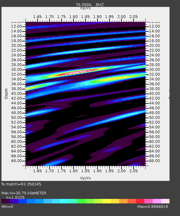
| Estimated Moho Depth: |
30.75 km |
| Estimated Crust Vp/Vs: |
1.82 |
| Assumed Crust Vp: |
6.419 km/s |
| Estimated Crust Vs: |
3.522 km/s |
| Estimated Crust Poisson's Ratio: |
0.28 |
|
| Radial Match: |
93.358345 % |
| Radial Bump: |
400 |
| Transverse Match: |
77.969185 % |
| Transverse Bump: |
400 |
| SOD ConfigId: |
512894 |
| Insert Time: |
2013-09-13 11:48:30.063 +0000 |
| GWidth: |
2.5 |
| Max Bumps: |
400 |
| Tol: |
0.001 |
|

Signal To Noise
| Channel | StoN | STA | LTA |
| TA:S58A: :BHZ:20130419T03:17:48.248999Z | 26.42858 | 3.9648935E-6 | 1.5002296E-7 |
| TA:S58A: :BHN:20130419T03:17:48.248999Z | 7.512231 | 1.2927178E-6 | 1.7208174E-7 |
| TA:S58A: :BHE:20130419T03:17:48.248999Z | 5.664727 | 1.122961E-6 | 1.9823744E-7 |
| Arrivals |
| Ps | 4.0 SECOND |
| PpPs | 13 SECOND |
| PsPs/PpSs | 17 SECOND |


