You are here: Home > Network List > TA - USArray Transportable Network (new EarthScope stations) Stations List
> Station SFIN Lafayette, IN, USA > Earthquake Result Viewer
SFIN Lafayette, IN, USA - Earthquake Result Viewer
| Earthquake location: |
Kuril Islands |
| Earthquake latitude/longitude: |
46.2/150.8 |
| Earthquake time(UTC): |
2013/04/19 (109) 03:05:52 GMT |
| Earthquake Depth: |
110 km |
| Earthquake Magnitude: |
7.2 MW, 7.1 MB, 7.2 MW |
| Earthquake Catalog/Contributor: |
NEIC PDE/NEIC PDE-W |
|
| Network: |
TA USArray Transportable Network (new EarthScope stations) |
| Station: |
SFIN Lafayette, IN, USA |
| Lat/Lon: |
40.38 N/87.10 W |
| Elevation: |
165 m |
|
| Distance: |
79.5 deg |
| Az: |
41.153 deg |
| Baz: |
323.266 deg |
| Ray Param: |
0.0486762 |
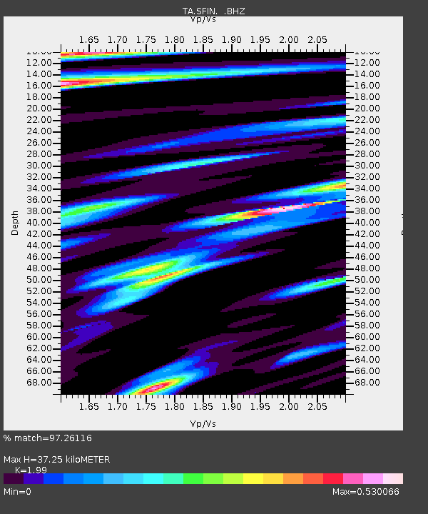
| Estimated Moho Depth: |
37.25 km |
| Estimated Crust Vp/Vs: |
1.99 |
| Assumed Crust Vp: |
6.498 km/s |
| Estimated Crust Vs: |
3.265 km/s |
| Estimated Crust Poisson's Ratio: |
0.33 |
|
| Radial Match: |
97.26116 % |
| Radial Bump: |
400 |
| Transverse Match: |
93.85235 % |
| Transverse Bump: |
400 |
| SOD ConfigId: |
512894 |
| Insert Time: |
2013-09-13 11:48:40.095 +0000 |
| GWidth: |
2.5 |
| Max Bumps: |
400 |
| Tol: |
0.001 |
|

Signal To Noise
| Channel | StoN | STA | LTA |
| TA:SFIN: :BHZ:20130419T03:17:16.050024Z | 25.443556 | 4.8031015E-6 | 1.8877478E-7 |
| TA:SFIN: :BHN:20130419T03:17:16.050024Z | 8.746337 | 1.3995524E-6 | 1.6001583E-7 |
| TA:SFIN: :BHE:20130419T03:17:16.050024Z | 10.89045 | 9.958015E-7 | 9.1438054E-8 |
| Arrivals |
| Ps | 5.8 SECOND |
| PpPs | 17 SECOND |
| PsPs/PpSs | 23 SECOND |


