You are here: Home > Network List > TA - USArray Transportable Network (new EarthScope stations) Stations List
> Station T56A Rocky Mt, VA, USA > Earthquake Result Viewer
T56A Rocky Mt, VA, USA - Earthquake Result Viewer

| Earthquake location: |
Kuril Islands |
| Earthquake latitude/longitude: |
46.2/150.8 |
| Earthquake time(UTC): |
2013/04/19 (109) 03:05:52 GMT |
| Earthquake Depth: |
110 km |
| Earthquake Magnitude: |
7.2 MW, 7.1 MB, 7.2 MW |
| Earthquake Catalog/Contributor: |
NEIC PDE/NEIC PDE-W |
|
| Network: |
TA USArray Transportable Network (new EarthScope stations) |
| Station: |
T56A Rocky Mt, VA, USA |
| Lat/Lon: |
37.03 N/80.03 W |
| Elevation: |
387 m |
|
| Distance: |
85.4 deg |
| Az: |
38.488 deg |
| Baz: |
327.32 deg |
| Ray Param: |
0.044567652 |
| Estimated Moho Depth: |
19.5 km |
| Estimated Crust Vp/Vs: |
1.90 |
| Assumed Crust Vp: |
6.159 km/s |
| Estimated Crust Vs: |
3.237 km/s |
| Estimated Crust Poisson's Ratio: |
0.31 |
|
| Radial Match: |
97.30139 % |
| Radial Bump: |
400 |
| Transverse Match: |
91.0998 % |
| Transverse Bump: |
400 |
| SOD ConfigId: |
512894 |
| Insert Time: |
2013-09-13 11:49:19.422 +0000 |
| GWidth: |
2.5 |
| Max Bumps: |
400 |
| Tol: |
0.001 |
|
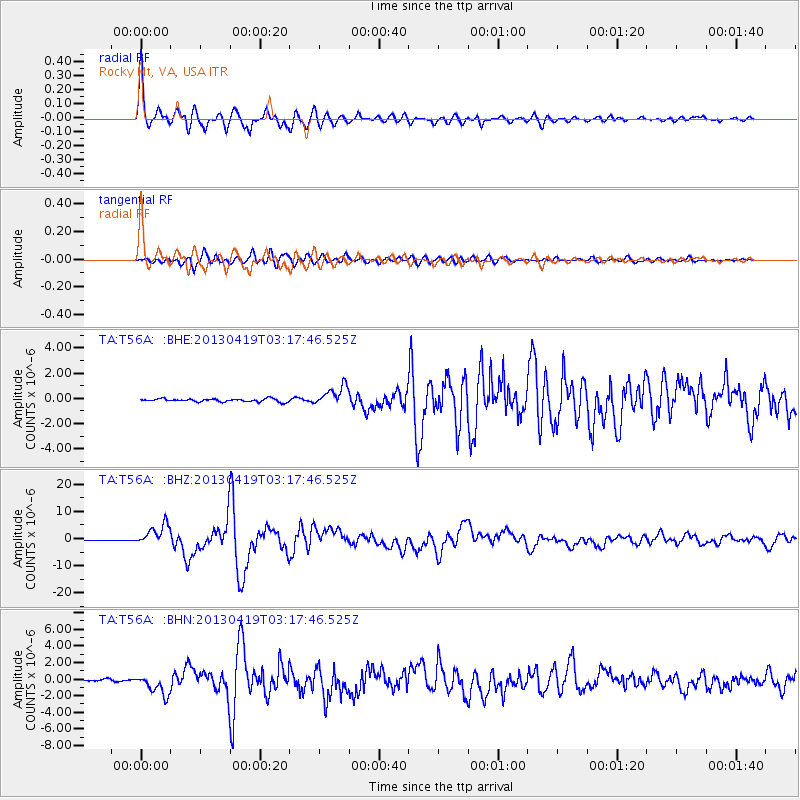
Signal To Noise
| Channel | StoN | STA | LTA |
| TA:T56A: :BHZ:20130419T03:17:46.525Z | 38.309868 | 3.9064835E-6 | 1.01970684E-7 |
| TA:T56A: :BHN:20130419T03:17:46.525Z | 8.503946 | 1.1896774E-6 | 1.398971E-7 |
| TA:T56A: :BHE:20130419T03:17:46.525Z | 6.493741 | 7.7856964E-7 | 1.1989539E-7 |
| Arrivals |
| Ps | 2.9 SECOND |
| PpPs | 9.0 SECOND |
| PsPs/PpSs | 12 SECOND |


